Mù Cang Chải elevation
Mù Cang Chải (Yên Bái), Vietnam elevation is 964 meters and Mù Cang Chải elevation in feet is 3163 ft above sea level [src 1]. Mù Cang Chải is a seat of a second-order administrative division (feature code) with elevation that is 836 meters (2743 ft) bigger than average city elevation in Vietnam.
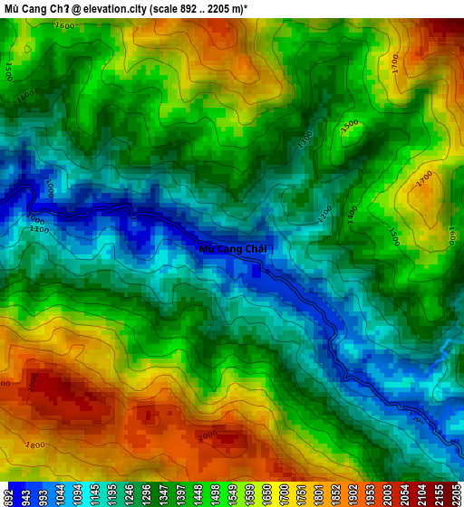
Below is the Elevation map of Mù Cang Chải, which displays elevation range with different colors. Scale of the first map is from 892 to 2205 m (2927 to 7234 ft) with average elevation of 1431.8 meters (=4698 ft) [note 1]
These maps also provides idea of topography and contour of this city, they are displayed at different zoom levels. More info about maps, scale and edge coordinates you can find below images.
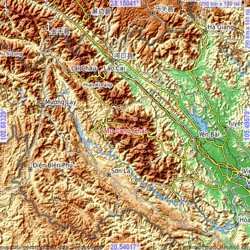
| \ | Map #1 | Topo.Map |
| Scale [m] | 892..2205 m | × |
| Scale [ft] | 2927..7234 ft | × |
| Average | 1431.8 m = 4698 ft | × |
| Width | 9.07 km = 5.6 mi | 290.2 km = 180.3 mi |
| Height | 9.07 km = 5.6 mi | 290.2 km = 180.3 mi |
| ↑Max Latitude | 21.892032° | 23.15041° |
| Latitude at center | 21.85125° | 21.85125° |
| ↓Min Latitude | 21.810456° | 20.54017° |
| ← Min Longitude | 104.045595° | 102.68329° |
| Longitude center | 104.08954° | 104.08954° |
| →Max Longitude | 104.133485° | 105.49579° |
Nearby cities:
Cities around Mù Cang Chải sort by population:
• Sơn La elevation 608 m
61.1 km,  196°
196°
• Sa Pa 1522 m
60 km,  335°
335°
• Lao Chải 1168 m
56.2 km, 336°
• Thị Trấn Thuận Châu 594 m
61.7 km,  221°
221°
• Sơn Thịnh 316 m
61.3 km,  121°
121°
• Thị Trấn Phố Ràng 87 m
58.3 km,  43°
43°
• Mường Chiên 160 m
54 km,  268°
268°
• Thị Trấn Phố Lu 77 m
53 km,  10°
10°
• Thị Trấn Trạm Tấu 691 m
52.2 km,  144°
144°
• Ít Ong 206 m
37.7 km,  189°
189°
• Thị Trấn Khánh Yên 202 m
31.3 km,  32°
32°
• Than Uyên 587 m
24.7 km,  299°
299°
Multilingual:
 En español:
Mù Cang Chải elevación 964 m.
 En France:
Mù Cang Chải élévation 964 m.
 Auf Deutsch:
Mù Cang Chải höhe über dem Meeresspiegel ist 964 m.

Sources and notes:
- [note 1] Map square and city borders are not equal. Map elevation data is calculated only from area inside that square.
- [src 1] Elevation data from geonames database provided with same terms of usage.
- [src 2] The elevation map of Mù Cang Chải is generated using elevation data from NASA's 3 arcsec (90m) resolution SRTM data.
- [src 3] Base (background) map © OpenStreetMap contributors tiles are generated by Geofabrik and OpenTopoMap.
Copyright & License:
This Mù Cang Chải Elevation Map is licensed under CC BY-SA. You may reuse any part from this page, if you give a proper credit by linking to this URL:
 More info on terms of use page.