Yên Bái elevation
Yên Bái, Vietnam elevation is 45 meters and Yên Bái elevation in feet is 148 ft above sea level [src 1]. Yên Bái is a seat of a first-order administrative division (feature code) with elevation that is 83 meters (272 ft) smaller than average city elevation in Vietnam.
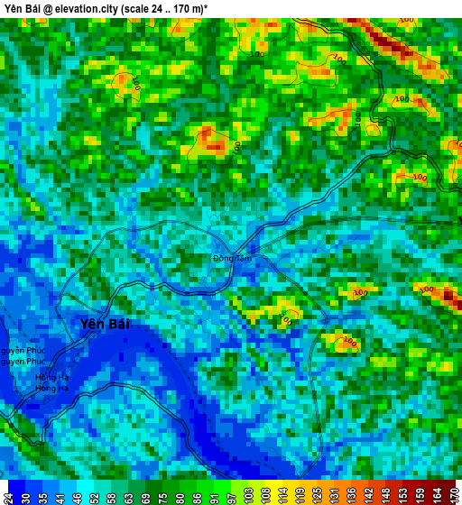
Below is the Elevation map of Yên Bái, which displays elevation range with different colors. Scale of the first map is from 24 to 170 m (79 to 558 ft) with average elevation of 64.1 meters (=210 ft) [note 1]
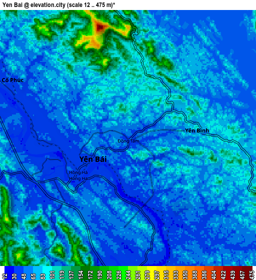
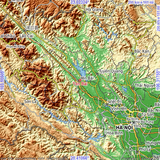
These maps also provides idea of topography and contour of this city, they are displayed at different zoom levels. More info about maps, scale and edge coordinates you can find below images.
| \ | Map #1 | Map #2 | Topo.Map |
| Scale [m] | 24..170 m | 12..475 m | × |
| Scale [ft] | 79..558 ft | 39..1558 ft | × |
| Average | 64.1 m = 210 ft | 74.4 m = 244 ft | × |
| Width | 9.08 km = 5.6 mi | 18.16 km = 11.3 mi | 290.5 km = 180.5 mi |
| Height | 9.08 km = 5.6 mi | 18.16 km = 11.3 mi | 290.5 km = 180.5 mi |
| ↑Max Latitude | 21.763699° | 21.804506° | 23.02324° |
| Latitude at center | 21.72288° | 21.72288° | 21.72288° |
| ↓Min Latitude | 21.68205° | 21.641208° | 20.41066° |
| ← Min Longitude | 104.867355° | 104.823409° | 103.50505° |
| Longitude center | 104.9113° | 104.9113° | 104.9113° |
| →Max Longitude | 104.955245° | 104.999191° | 106.31755° |
Nearby cities:
Cities around Yên Bái sort by population:
• Tuyên Quang elevation 35 m
33.2 km,  70°
70°
• Sơn Dương 63 m
50.5 km,  93°
93°
• Phú Thọ 32 m
48.2 km,  138°
138°
• Thị Trấn Yên Thế 96 m
45.6 km,  341°
341°
• Yên Lập 70 m
44.4 km,  160°
160°
• Sông Thao 44 m
40.7 km,  145°
145°
• Thị Trấn Tân Yên 45 m
40.2 km,  18°
18°
• Sơn Thịnh 316 m
37.3 km,  241°
241°
• Thanh Ba 47 m
34.4 km, 136°
• Đoan Hùng 23 m
30.4 km,  111°
111°
• Hạ Hòa 30 m
20.2 km, 151°
• Cổ Phúc 41 m
9.4 km,  292°
292°
Multilingual:
 En español:
Yên Bái elevación 45 m.
 En France:
Yên Bái élévation 45 m.


Sources and notes:
- [note 1] Map square and city borders are not equal. Map elevation data is calculated only from area inside that square.
- [src 1] Elevation data from geonames database provided with same terms of usage.
- [src 2] The elevation map of Yên Bái is generated using elevation data from NASA's 3 arcsec (90m) resolution SRTM data.
- [src 3] Base (background) map © OpenStreetMap contributors tiles are generated by Geofabrik and OpenTopoMap.
Copyright & License:
This Yên Bái Elevation Map is licensed under CC BY-SA. You may reuse any part from this page, if you give a proper credit by linking to this URL:
 More info on terms of use page.