Guasdualito elevation
Guasdualito (Apure), Venezuela elevation is 130 meters and Guasdualito elevation in feet is 427 ft above sea level [src 1]. Guasdualito is a seat of a second-order administrative division (feature code) with elevation that is 251 meters (823 ft) smaller than average city elevation in Venezuela.
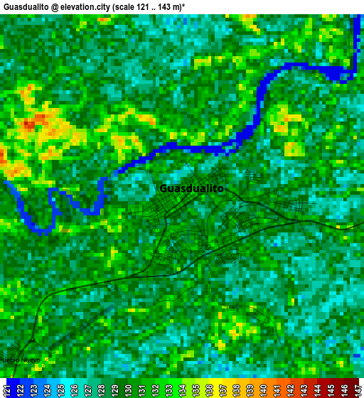
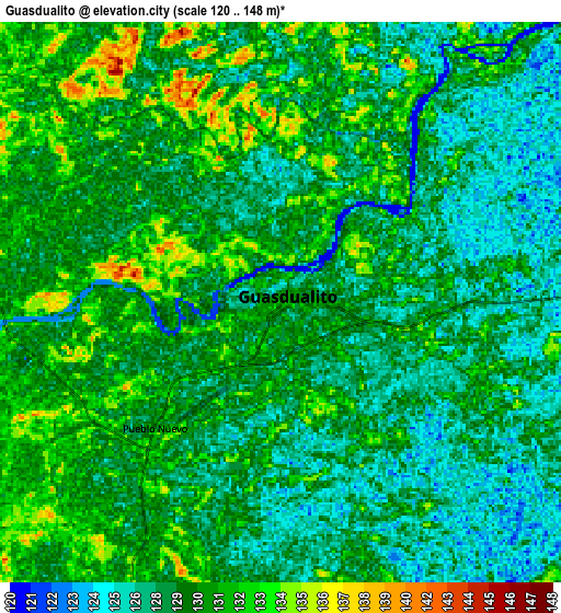
Below is the Elevation map of Guasdualito, which displays elevation range with different colors. Scale of the first map is from 121 to 143 m (397 to 469 ft) with average elevation of 129.1 meters (=424 ft) [note 1]
These maps also provides idea of topography and contour of this city, they are displayed at different zoom levels. More info about maps, scale and edge coordinates you can find below images.
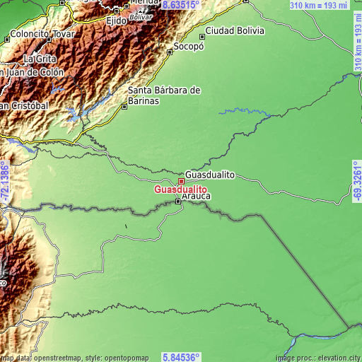
| \ | Map #1 | Map #2 | Topo.Map |
| Scale [m] | 121..143 m | 120..148 m | × |
| Scale [ft] | 397..469 ft | 394..486 ft | × |
| Average | 129.1 m = 424 ft | 129.1 m = 424 ft | × |
| Width | 9.69 km = 6 mi | 19.39 km = 12 mi | 310.2 km = 192.7 mi |
| Height | 9.69 km = 6 mi | 19.39 km = 12 mi | 310.2 km = 192.7 mi |
| ↑Max Latitude | 7.286003° | 7.329591° | 8.63515° |
| Latitude at center | 7.24241° | 7.24241° | 7.24241° |
| ↓Min Latitude | 7.198813° | 7.155212° | 5.84536° |
| ← Min Longitude | -70.776295° | -70.820241° | -72.1386° |
| Longitude center | -70.73235° | -70.73235° | -70.73235° |
| →Max Longitude | -70.688405° | -70.644459° | -69.3261° |
Nearby cities:
Cities around Guasdualito sort by population:
• Bum Bum elevation 209 m
115.1 km,  358°
358°
• Socopó 240 m
110.3 km,  354°
354°
• Chameta 213 m
97.3 km, 348°
• Santa María de Caparo 206 m
96.3 km,  303°
303°
• Abejales 223 m
95.7 km, 296°
• Punta de Piedra 179 m
93.5 km, 296°
• Capitanejo 244 m
90.6 km,  340°
340°
• Pedraza La Vieja 205 m
83.2 km,  334°
334°
• Santa Bárbara 187 m
80.3 km,  322°
322°
• El Cantón 152 m
67.5 km,  292°
292°
• Santa Cruz de Guacas 155 m
66.6 km, 289°
• Maporal 115 m
56.5 km,  37°
37°
Multilingual:
 En español:
Guasdualito elevación 130 m.
 En France:
Guasdualito élévation 130 m.
 Auf Deutsch:
Guasdualito höhe über dem Meeresspiegel ist 130 m.

Sources and notes:
- [note 1] Map square and city borders are not equal. Map elevation data is calculated only from area inside that square.
- [src 1] Elevation data from geonames database provided with same terms of usage.
- [src 2] The elevation map of Guasdualito is generated using elevation data from NASA's 3 arcsec (90m) resolution SRTM data.
- [src 3] Base (background) map © OpenStreetMap contributors tiles are generated by Geofabrik and OpenTopoMap.
Copyright & License:
This Guasdualito Elevation Map is licensed under CC BY-SA. You may reuse any part from this page, if you give a proper credit by linking to this URL:
 More info on terms of use page.