Abejales elevation
Abejales (Táchira, Municipio Libertador), Venezuela elevation is 223 meters and Abejales elevation in feet is 732 ft above sea level [src 1]. Abejales is a seat of a second-order administrative division (feature code) with elevation that is 158 meters (518 ft) smaller than average city elevation in Venezuela.
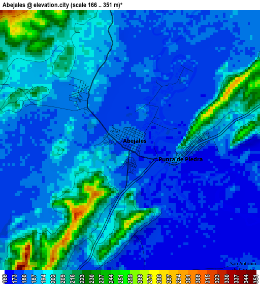
Below is the Elevation map of Abejales, which displays elevation range with different colors. Scale of the first map is from 166 to 351 m (545 to 1152 ft) with average elevation of 191.8 meters (=629 ft) [note 1]
These maps also provides idea of topography and contour of this city, they are displayed at different zoom levels. More info about maps, scale and edge coordinates you can find below images.
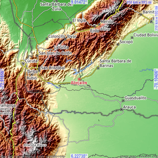
| \ | Map #1 | Topo.Map |
| Scale [m] | 166..351 m | × |
| Scale [ft] | 545..1152 ft | × |
| Average | 191.8 m = 629 ft | × |
| Width | 9.69 km = 6 mi | 309.9 km = 192.6 mi |
| Height | 9.69 km = 6 mi | 310 km = 192.6 mi |
| ↑Max Latitude | 7.666855° | 9.01472° |
| Latitude at center | 7.6233° | 7.6233° |
| ↓Min Latitude | 7.579741° | 6.22735° |
| ← Min Longitude | -71.554255° | -72.91656° |
| Longitude center | -71.51031° | -71.51031° |
| →Max Longitude | -71.466365° | -70.10406° |
Nearby cities:
Cities around Abejales sort by population:
• Guaraque elevation 1557 m
64 km,  337°
337°
• San José de Bolívar 1577 m
60.2 km,  302°
302°
• Pedraza La Vieja 205 m
59.4 km,  56°
56°
• Canaguá 1467 m
56 km,  5°
5°
• Pregonero 1254 m
52.2 km,  327°
327°
• San Rafael del Piñal 270 m
50.6 km,  258°
258°
• Santa Bárbara 187 m
42.3 km, 60°
• Puerto Vivas 208 m
39.3 km,  249°
249°
• Santa Cruz de Guacas 155 m
30.5 km,  130°
130°
• El Cantón 152 m
28.5 km,  124°
124°
• Santa María de Caparo 206 m
11.3 km,  26°
26°
• Punta de Piedra 179 m
2.2 km,  107°
107°
Multilingual:
 En español:
Abejales elevación 223 m.
 En France:
Abejales élévation 223 m.
 Auf Deutsch:
Abejales höhe über dem Meeresspiegel ist 223 m.

Sources and notes:
- [note 1] Map square and city borders are not equal. Map elevation data is calculated only from area inside that square.
- [src 1] Elevation data from geonames database provided with same terms of usage.
- [src 2] The elevation map of Abejales is generated using elevation data from NASA's 3 arcsec (90m) resolution SRTM data.
- [src 3] Base (background) map © OpenStreetMap contributors tiles are generated by Geofabrik and OpenTopoMap.
Copyright & License:
This Abejales Elevation Map is licensed under CC BY-SA. You may reuse any part from this page, if you give a proper credit by linking to this URL:
 More info on terms of use page.