San Rafael del Piñal elevation
San Rafael del Piñal (Táchira, Municipio Fernández Feo), Venezuela elevation is 270 meters and San Rafael del Piñal elevation in feet is 886 ft above sea level [src 1]. San Rafael del Piñal is a seat of a second-order administrative division (feature code) with elevation that is 111 meters (364 ft) smaller than average city elevation in Venezuela.
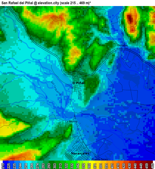
Below is the Elevation map of San Rafael del Piñal, which displays elevation range with different colors. Scale of the first map is from 215 to 469 m (705 to 1539 ft) with average elevation of 275 meters (=902 ft) [note 1]
These maps also provides idea of topography and contour of this city, they are displayed at different zoom levels. More info about maps, scale and edge coordinates you can find below images.
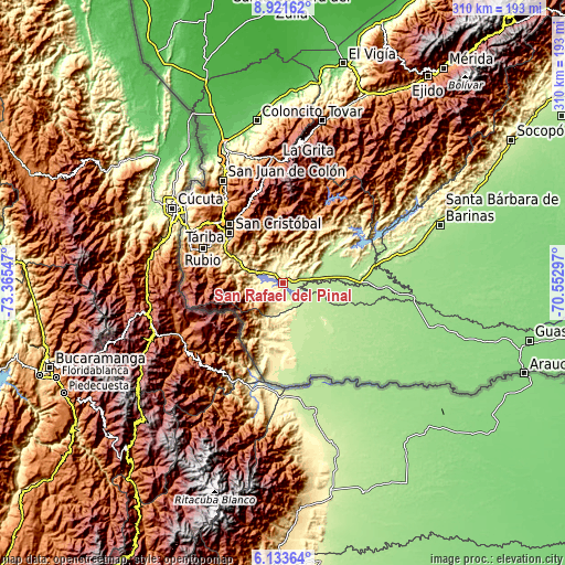
| \ | Map #1 | Topo.Map |
| Scale [m] | 215..469 m | × |
| Scale [ft] | 705..1539 ft | × |
| Average | 275 m = 902 ft | × |
| Width | 9.69 km = 6 mi | 310 km = 192.6 mi |
| Height | 9.69 km = 6 mi | 310 km = 192.6 mi |
| ↑Max Latitude | 7.573434° | 8.92162° |
| Latitude at center | 7.52987° | 7.52987° |
| ↓Min Latitude | 7.486301° | 6.13364° |
| ← Min Longitude | -72.003165° | -73.36547° |
| Longitude center | -71.95922° | -71.95922° |
| →Max Longitude | -71.915275° | -70.55297° |
Nearby cities:
Cities around San Rafael del Piñal sort by population:
• San Cristóbal elevation 899 m
39.4 km,  311°
311°
• Rubio 833 m
47.7 km,  293°
293°
• Táriba 885 m
43.4 km,  317°
317°
• Abejales 223 m
50.6 km,  78°
78°
• Capacho Nuevo 1282 m
50.5 km, 310°
• Palmira 1123 m
45.2 km, 319°
• Cordero 1227 m
43.8 km,  326°
326°
• Queniquea 1685 m
43.4 km,  352°
352°
• San José de Bolívar 1577 m
42.6 km,  358°
358°
• Santa Ana 639 m
37.2 km, 289°
• San Josecito 672 m
32.2 km,  296°
296°
• Puerto Vivas 208 m
13.1 km,  104°
104°
Multilingual:
 En español:
San Rafael del Piñal elevación 270 m.
 En France:
San Rafael del Piñal élévation 270 m.
 Auf Deutsch:
San Rafael del Piñal höhe über dem Meeresspiegel ist 270 m.
 На русском:
San Rafael del Piñal высота над уровнем моря 270 м
Sources and notes:
- [note 1] Map square and city borders are not equal. Map elevation data is calculated only from area inside that square.
- [src 1] Elevation data from geonames database provided with same terms of usage.
- [src 2] The elevation map of San Rafael del Piñal is generated using elevation data from NASA's 3 arcsec (90m) resolution SRTM data.
- [src 3] Base (background) map © OpenStreetMap contributors tiles are generated by Geofabrik and OpenTopoMap.
Copyright & License:
This San Rafael del Piñal Elevation Map is licensed under CC BY-SA. You may reuse any part from this page, if you give a proper credit by linking to this URL:
 More info on terms of use page.