Táriba elevation
Táriba (Táchira, Municipio Cárdenas), Venezuela elevation is 885 meters and Táriba elevation in feet is 2904 ft above sea level [src 1]. Táriba is a seat of a second-order administrative division (feature code) with elevation that is 504 meters (1654 ft) bigger than average city elevation in Venezuela.
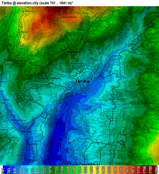
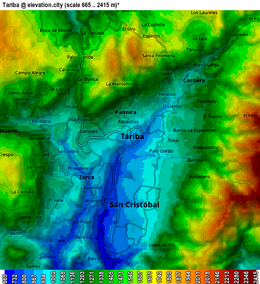
Below is the Elevation map of Táriba, which displays elevation range with different colors. Scale of the first map is from 741 to 1841 m (2431 to 6040 ft) with average elevation of 1066.2 meters (=3498 ft) [note 1]
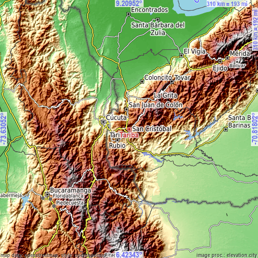
These maps also provides idea of topography and contour of this city, they are displayed at different zoom levels. More info about maps, scale and edge coordinates you can find below images.
| \ | Map #1 | Map #2 | Topo.Map |
| Scale [m] | 741..1841 m | 665..2415 m | × |
| Scale [ft] | 2431..6040 ft | 2182..7923 ft | × |
| Average | 1066.2 m = 3498 ft | 1317.8 m = 4323 ft | × |
| Width | 9.68 km = 6 mi | 19.36 km = 12 mi | 309.8 km = 192.5 mi |
| Height | 9.68 km = 6 mi | 19.36 km = 12 mi | 309.8 km = 192.5 mi |
| ↑Max Latitude | 7.862334° | 7.905864° | 9.20952° |
| Latitude at center | 7.8188° | 7.8188° | 7.8188° |
| ↓Min Latitude | 7.775261° | 7.731717° | 6.42343° |
| ← Min Longitude | -72.268215° | -72.312161° | -73.63052° |
| Longitude center | -72.22427° | -72.22427° | -72.22427° |
| →Max Longitude | -72.180325° | -72.136379° | -70.81802° |
Nearby cities:
Cities around Táriba sort by population:
• San Cristóbal elevation 899 m
5.8 km,  180°
180°
• Rubio 833 m
19.5 km,  227°
227°
• Colón 805 m
24 km,  350°
350°
• San Antonio del Táchira 430 m
24.1 km,  268°
268°
• Santa Ana 639 m
20.5 km,  196°
196°
• San Josecito 672 m
17.5 km, 178°
• Michelena 1248 m
15.5 km, 352°
• Lobatera 960 m
12.6 km, 348°
• Capacho Viejo 1309 m
10.5 km,  276°
276°
• Capacho Nuevo 1282 m
9.3 km, 274°
• Cordero 1227 m
6.4 km,  48°
48°
• Palmira 1123 m
2.1 km, 348°
Multilingual:
 En español:
Táriba elevación 885 m.
 En France:
Táriba élévation 885 m.


Sources and notes:
- [note 1] Map square and city borders are not equal. Map elevation data is calculated only from area inside that square.
- [src 1] Elevation data from geonames database provided with same terms of usage.
- [src 2] The elevation map of Táriba is generated using elevation data from NASA's 3 arcsec (90m) resolution SRTM data.
- [src 3] Base (background) map © OpenStreetMap contributors tiles are generated by Geofabrik and OpenTopoMap.
Copyright & License:
This Táriba Elevation Map is licensed under CC BY-SA. You may reuse any part from this page, if you give a proper credit by linking to this URL:
 More info on terms of use page.