San Antonio del Táchira elevation
San Antonio del Táchira (Táchira, Municipio Bolívar), Venezuela elevation is 430 meters and San Antonio del Táchira elevation in feet is 1411 ft above sea level [src 1]. San Antonio del Táchira is a seat of a second-order administrative division (feature code) with elevation that is 49 meters (161 ft) bigger than average city elevation in Venezuela.
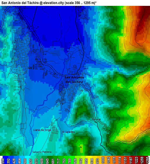
Below is the Elevation map of San Antonio del Táchira, which displays elevation range with different colors. Scale of the first map is from 356 to 1295 m (1168 to 4249 ft) with average elevation of 577 meters (=1893 ft) [note 1]
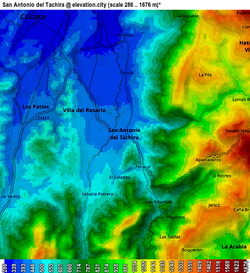
These maps also provides idea of topography and contour of this city, they are displayed at different zoom levels. More info about maps, scale and edge coordinates you can find below images.
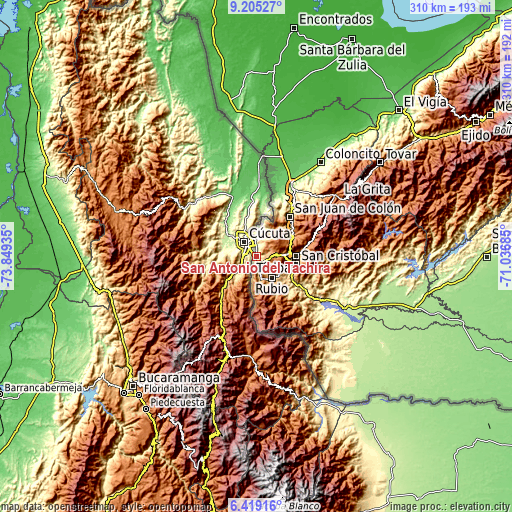
| \ | Map #1 | Map #2 | Topo.Map |
| Scale [m] | 356..1295 m | 286..1676 m | × |
| Scale [ft] | 1168..4249 ft | 938..5499 ft | × |
| Average | 577 m = 1893 ft | 720.5 m = 2364 ft | × |
| Width | 9.68 km = 6 mi | 19.36 km = 12 mi | 309.8 km = 192.5 mi |
| Height | 9.68 km = 6 mi | 19.36 km = 12 mi | 309.8 km = 192.5 mi |
| ↑Max Latitude | 7.858075° | 7.901605° | 9.20527° |
| Latitude at center | 7.81454° | 7.81454° | 7.81454° |
| ↓Min Latitude | 7.771001° | 7.727457° | 6.41916° |
| ← Min Longitude | -72.487045° | -72.530991° | -73.84935° |
| Longitude center | -72.4431° | -72.4431° | -72.4431° |
| →Max Longitude | -72.399155° | -72.355209° | -71.03685° |
Nearby cities:
Cities around San Antonio del Táchira sort by population:
• San Cristóbal elevation 899 m
24.6 km,  102°
102°
• Rubio 833 m
15.9 km,  142°
142°
• Táriba 885 m
24.1 km,  88°
88°
• Cordero 1227 m
29.3 km,  80°
80°
• Delicias 1549 m
27.7 km,  181°
181°
• Michelena 1248 m
27.1 km,  54°
54°
• Santa Ana 639 m
26.5 km, 136°
• Lobatera 960 m
25.1 km,  59°
59°
• Palmira 1123 m
23.8 km, 83°
• Capacho Nuevo 1282 m
14.9 km, 85°
• Capacho Viejo 1309 m
13.7 km, 83°
• Ureña 345 m
11.6 km,  357°
357°
Multilingual:
 En español:
San Antonio del Táchira elevación 430 m.
 En France:
San Antonio del Táchira élévation 430 m.
 Auf Deutsch:
San Antonio del Táchira höhe über dem Meeresspiegel ist 430 m.
 На русском:
San Antonio del Táchira высота над уровнем моря 430 м
Sources and notes:
- [note 1] Map square and city borders are not equal. Map elevation data is calculated only from area inside that square.
- [src 1] Elevation data from geonames database provided with same terms of usage.
- [src 2] The elevation map of San Antonio del Táchira is generated using elevation data from NASA's 3 arcsec (90m) resolution SRTM data.
- [src 3] Base (background) map © OpenStreetMap contributors tiles are generated by Geofabrik and OpenTopoMap.
Copyright & License:
This San Antonio del Táchira Elevation Map is licensed under CC BY-SA. You may reuse any part from this page, if you give a proper credit by linking to this URL:
 More info on terms of use page.