Chameta elevation
Chameta (Barinas, Municipio Antonio José de Sucre), Venezuela elevation is 213 meters and Chameta elevation in feet is 699 ft above sea level [src 1]. Chameta is a seat of a third-order administrative division (feature code) with elevation that is 168 meters (551 ft) smaller than average city elevation in Venezuela.
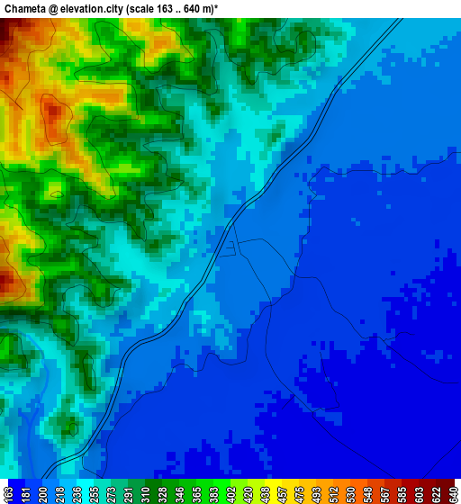
Below is the Elevation map of Chameta, which displays elevation range with different colors. Scale of the first map is from 163 to 640 m (535 to 2100 ft) with average elevation of 253.9 meters (=833 ft) [note 1]
These maps also provides idea of topography and contour of this city, they are displayed at different zoom levels. More info about maps, scale and edge coordinates you can find below images.
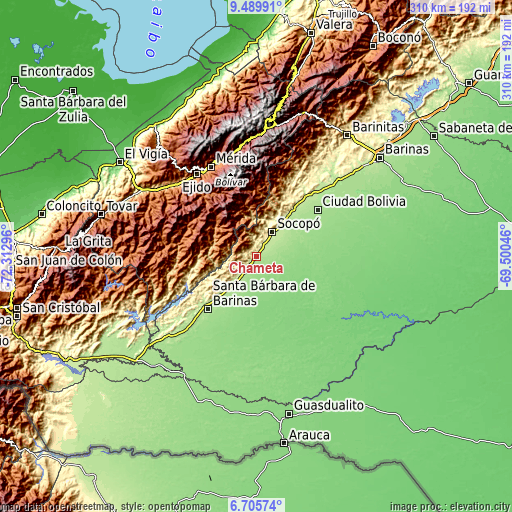
| \ | Map #1 | Topo.Map |
| Scale [m] | 163..640 m | × |
| Scale [ft] | 535..2100 ft | × |
| Average | 253.9 m = 833 ft | × |
| Width | 9.67 km = 6 mi | 309.6 km = 192.4 mi |
| Height | 9.68 km = 6 mi | 309.6 km = 192.4 mi |
| ↑Max Latitude | 8.143735° | 9.48991° |
| Latitude at center | 8.10023° | 8.10023° |
| ↓Min Latitude | 8.056721° | 6.70574° |
| ← Min Longitude | -70.950655° | -72.31296° |
| Longitude center | -70.90671° | -70.90671° |
| →Max Longitude | -70.862765° | -69.50046° |
Nearby cities:
Cities around Chameta sort by population:
• Mérida elevation 1544 m
61 km,  333°
333°
• Mucumpiz 2236 m
43.1 km,  324°
324°
• Ejido 1143 m
61.8 km, 323°
• Canaguá 1467 m
61 km,  272°
272°
• Curbatí 208 m
55.3 km,  44°
44°
• Ciudad Bolivia 175 m
46.4 km,  52°
52°
• Santa Bárbara 187 m
43.7 km,  223°
223°
• Aricagua 943 m
28.9 km,  298°
298°
• Pedraza La Vieja 205 m
26.4 km, 219°
• Bum Bum 209 m
24.9 km, 38°
• Socopó 240 m
17.2 km,  32°
32°
• Capitanejo 244 m
14.6 km,  227°
227°
Multilingual:
 En español:
Chameta elevación 213 m.
 En France:
Chameta élévation 213 m.


Sources and notes:
- [note 1] Map square and city borders are not equal. Map elevation data is calculated only from area inside that square.
- [src 1] Elevation data from geonames database provided with same terms of usage.
- [src 2] The elevation map of Chameta is generated using elevation data from NASA's 3 arcsec (90m) resolution SRTM data.
- [src 3] Base (background) map © OpenStreetMap contributors tiles are generated by Geofabrik and OpenTopoMap.
Copyright & License:
This Chameta Elevation Map is licensed under CC BY-SA. You may reuse any part from this page, if you give a proper credit by linking to this URL:
 More info on terms of use page.