Barrancas elevation
Barrancas (Barinas, Municipio Cruz Paredes), Venezuela elevation is 284 meters and Barrancas elevation in feet is 932 ft above sea level [src 1]. Barrancas is a seat of a second-order administrative division (feature code) with elevation that is 97 meters (318 ft) smaller than average city elevation in Venezuela.
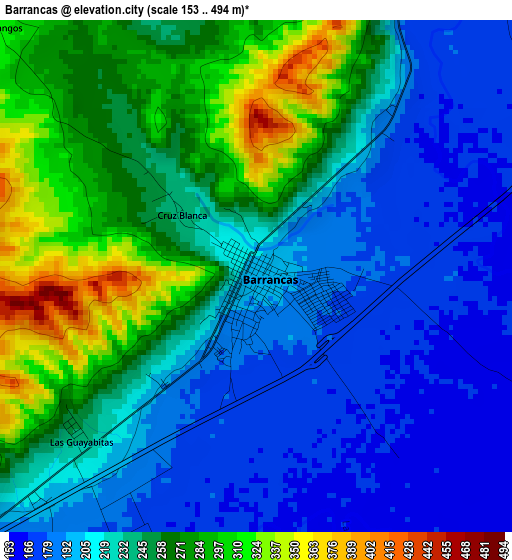
Below is the Elevation map of Barrancas, which displays elevation range with different colors. Scale of the first map is from 153 to 494 m (502 to 1621 ft) with average elevation of 234 meters (=768 ft) [note 1]
These maps also provides idea of topography and contour of this city, they are displayed at different zoom levels. More info about maps, scale and edge coordinates you can find below images.
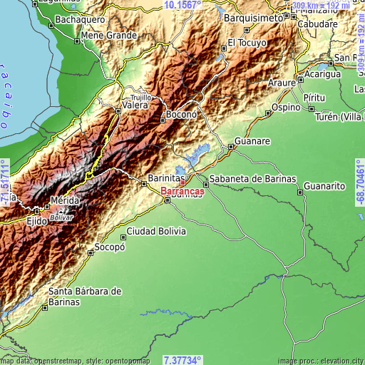
| \ | Map #1 | Topo.Map |
| Scale [m] | 153..494 m | × |
| Scale [ft] | 502..1621 ft | × |
| Average | 234 m = 768 ft | × |
| Width | 9.66 km = 6 mi | 309 km = 192 mi |
| Height | 9.66 km = 6 mi | 309.1 km = 192.1 mi |
| ↑Max Latitude | 8.813049° | 10.1567° |
| Latitude at center | 8.76962° | 8.76962° |
| ↓Min Latitude | 8.726186° | 7.37734° |
| ← Min Longitude | -70.154805° | -71.51711° |
| Longitude center | -70.11086° | -70.11086° |
| →Max Longitude | -70.066915° | -68.70461° |
Nearby cities:
Cities around Barrancas sort by population:
• Barinas elevation 187 m
19.5 km,  213°
213°
• Alto Barinas 194 m
23.4 km, 212°
• Barinitas 463 m
33.1 km,  268°
268°
• Torunos 142 m
30.1 km,  173°
173°
• Caramuca 227 m
30 km,  230°
230°
• Quebrada Seca 308 m
24.2 km,  251°
251°
• Sabaneta 143 m
19.6 km,  95°
95°
• Obispos 159 m
18.1 km,  177°
177°
• Los Guasimitos 206 m
17.7 km, 228°
• Boconoito 190 m
16.7 km,  59°
59°
• Veguitas 164 m
14 km, 64°
• La Yuca 224 m
8.8 km,  240°
240°
Multilingual:
 En español:
Barrancas elevación 284 m.
 En France:
Barrancas élévation 284 m.
 Auf Deutsch:
Barrancas höhe über dem Meeresspiegel ist 284 m.

Sources and notes:
- [note 1] Map square and city borders are not equal. Map elevation data is calculated only from area inside that square.
- [src 1] Elevation data from geonames database provided with same terms of usage.
- [src 2] The elevation map of Barrancas is generated using elevation data from NASA's 3 arcsec (90m) resolution SRTM data.
- [src 3] Base (background) map © OpenStreetMap contributors tiles are generated by Geofabrik and OpenTopoMap.
Copyright & License:
This Barrancas Elevation Map is licensed under CC BY-SA. You may reuse any part from this page, if you give a proper credit by linking to this URL:
 More info on terms of use page.