Barinitas elevation
Barinitas (Barinas, Municipio Bolívar), Venezuela elevation is 463 meters and Barinitas elevation in feet is 1519 ft above sea level [src 1]. Barinitas is a seat of a second-order administrative division (feature code) with elevation that is 82 meters (269 ft) bigger than average city elevation in Venezuela.
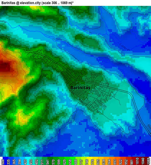
Below is the Elevation map of Barinitas, which displays elevation range with different colors. Scale of the first map is from 306 to 1069 m (1004 to 3507 ft) with average elevation of 477.7 meters (=1567 ft) [note 1]
These maps also provides idea of topography and contour of this city, they are displayed at different zoom levels. More info about maps, scale and edge coordinates you can find below images.
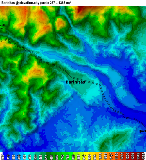
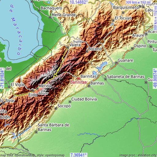
| \ | Map #1 | Map #2 | Topo.Map |
| Scale [m] | 306..1069 m | 267..1385 m | × |
| Scale [ft] | 1004..3507 ft | 876..4544 ft | × |
| Average | 477.7 m = 1567 ft | 535.5 m = 1757 ft | × |
| Width | 9.66 km = 6 mi | 19.32 km = 12 mi | 309 km = 192 mi |
| Height | 9.66 km = 6 mi | 19.32 km = 12 mi | 309.1 km = 192.1 mi |
| ↑Max Latitude | 8.80514° | 8.848565° | 10.14882° |
| Latitude at center | 8.76171° | 8.76171° | 8.76171° |
| ↓Min Latitude | 8.718275° | 8.674835° | 7.36941° |
| ← Min Longitude | -70.455935° | -70.499881° | -71.81824° |
| Longitude center | -70.41199° | -70.41199° | -70.41199° |
| →Max Longitude | -70.368045° | -70.324099° | -69.00574° |
Nearby cities:
Cities around Barinitas sort by population:
• Barinas elevation 187 m
27.3 km,  124°
124°
• Alto Barinas 194 m
27.7 km,  132°
132°
• Pueblo Llano 2161 m
32.1 km,  302°
302°
• Masparrito 1062 m
29.3 km,  24°
24°
• La Yuca 224 m
25.6 km,  97°
97°
• Los Guasimitos 206 m
22.5 km, 118°
• El Corozo 213 m
22.4 km,  164°
164°
• La Mula 222 m
21.6 km,  169°
169°
• Caramuca 227 m
20.9 km,  151°
151°
• Calderas 908 m
17.4 km,  347°
347°
• Quebrada Seca 308 m
12.3 km, 123°
• Altamira 816 m
12.1 km, 304°
Multilingual:
 En español:
Barinitas elevación 463 m.
 En France:
Barinitas élévation 463 m.
 Auf Deutsch:
Barinitas höhe über dem Meeresspiegel ist 463 m.

Sources and notes:
- [note 1] Map square and city borders are not equal. Map elevation data is calculated only from area inside that square.
- [src 1] Elevation data from geonames database provided with same terms of usage.
- [src 2] The elevation map of Barinitas is generated using elevation data from NASA's 3 arcsec (90m) resolution SRTM data.
- [src 3] Base (background) map © OpenStreetMap contributors tiles are generated by Geofabrik and OpenTopoMap.
Copyright & License:
This Barinitas Elevation Map is licensed under CC BY-SA. You may reuse any part from this page, if you give a proper credit by linking to this URL:
 More info on terms of use page.