Obispos elevation
Obispos (Barinas, Municipio Obispos), Venezuela elevation is 159 meters and Obispos elevation in feet is 522 ft above sea level [src 1]. Obispos is a seat of a second-order administrative division (feature code) with elevation that is 222 meters (728 ft) smaller than average city elevation in Venezuela.
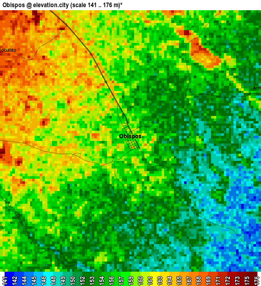
Below is the Elevation map of Obispos, which displays elevation range with different colors. Scale of the first map is from 141 to 176 m (463 to 577 ft) with average elevation of 156.5 meters (=513 ft) [note 1]
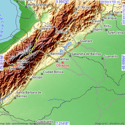
These maps also provides idea of topography and contour of this city, they are displayed at different zoom levels. More info about maps, scale and edge coordinates you can find below images.
| \ | Map #1 | Topo.Map |
| Scale [m] | 141..176 m | × |
| Scale [ft] | 463..577 ft | × |
| Average | 156.5 m = 513 ft | × |
| Width | 9.66 km = 6 mi | 309.2 km = 192.1 mi |
| Height | 9.66 km = 6 mi | 309.2 km = 192.1 mi |
| ↑Max Latitude | 8.650458° | 9.99474° |
| Latitude at center | 8.60701° | 8.60701° |
| ↓Min Latitude | 8.563557° | 7.21418° |
| ← Min Longitude | -70.148835° | -71.51114° |
| Longitude center | -70.10489° | -70.10489° |
| →Max Longitude | -70.060945° | -68.69864° |
Nearby cities:
Cities around Obispos sort by population:
• Barinas elevation 187 m
11.4 km,  278°
278°
• Alto Barinas 194 m
13.4 km,  263°
263°
• El Corozo 213 m
28.1 km, 261°
• Veguitas 164 m
26.9 km,  26°
26°
• Quebrada Seca 308 m
25.8 km,  293°
293°
• Sabaneta 143 m
24.8 km,  49°
49°
• Caramuca 227 m
23.7 km,  267°
267°
• El Real 132 m
22.5 km,  147°
147°
• Barrancas 284 m
18.1 km,  357°
357°
• La Yuca 224 m
16.1 km,  328°
328°
• Los Guasimitos 206 m
15.4 km, 294°
• Torunos 142 m
12.2 km,  167°
167°
Multilingual:
 En español:
Obispos elevación 159 m.
 En France:
Obispos élévation 159 m.


Sources and notes:
- [note 1] Map square and city borders are not equal. Map elevation data is calculated only from area inside that square.
- [src 1] Elevation data from geonames database provided with same terms of usage.
- [src 2] The elevation map of Obispos is generated using elevation data from NASA's 3 arcsec (90m) resolution SRTM data.
- [src 3] Base (background) map © OpenStreetMap contributors tiles are generated by Geofabrik and OpenTopoMap.
Copyright & License:
This Obispos Elevation Map is licensed under CC BY-SA. You may reuse any part from this page, if you give a proper credit by linking to this URL:
 More info on terms of use page.