Guanarito elevation
Guanarito (Portuguesa, Municipio Guanarito), Venezuela elevation is 93 meters and Guanarito elevation in feet is 305 ft above sea level [src 1]. Guanarito is a seat of a second-order administrative division (feature code) with elevation that is 288 meters (945 ft) smaller than average city elevation in Venezuela.
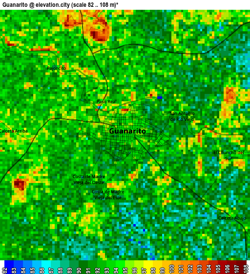
Below is the Elevation map of Guanarito, which displays elevation range with different colors. Scale of the first map is from 82 to 108 m (269 to 354 ft) with average elevation of 92.1 meters (=302 ft) [note 1]
These maps also provides idea of topography and contour of this city, they are displayed at different zoom levels. More info about maps, scale and edge coordinates you can find below images.
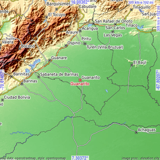
| \ | Map #1 | Topo.Map |
| Scale [m] | 82..108 m | × |
| Scale [ft] | 269..354 ft | × |
| Average | 92.1 m = 302 ft | × |
| Width | 9.66 km = 6 mi | 309.1 km = 192.1 mi |
| Height | 9.66 km = 6 mi | 309.1 km = 192.1 mi |
| ↑Max Latitude | 8.739688° | 10.08362° |
| Latitude at center | 8.69625° | 8.69625° |
| ↓Min Latitude | 8.652807° | 7.30372° |
| ← Min Longitude | -69.252265° | -70.61457° |
| Longitude center | -69.20832° | -69.20832° |
| →Max Longitude | -69.164375° | -67.80207° |
Nearby cities:
Cities around Guanarito sort by population:
• Guanare elevation 164 m
70.1 km,  303°
303°
• Villa Bruzual 122 m
71.3 km,  7°
7°
• Puerto de Nutrias 83 m
70.1 km,  188°
188°
• Ciudad De Nutrias 84 m
67.7 km, 189°
• Libertad 83 m
62 km,  228°
228°
• Santa Rosa 113 m
61.2 km,  242°
242°
• Dolores 100 m
60.2 km,  220°
220°
• Las Casitas del Vegon de Nutrias 90 m
56 km,  204°
204°
• Arauquita 124 m
49.4 km,  271°
271°
• El Playón 82 m
48.4 km,  21°
21°
• Papelón 109 m
38.8 km,  314°
314°
• El Regalo 86 m
29.3 km,  173°
173°
Multilingual:
 En español:
Guanarito elevación 93 m.
 En France:
Guanarito élévation 93 m.
 Auf Deutsch:
Guanarito höhe über dem Meeresspiegel ist 93 m.

Sources and notes:
- [note 1] Map square and city borders are not equal. Map elevation data is calculated only from area inside that square.
- [src 1] Elevation data from geonames database provided with same terms of usage.
- [src 2] The elevation map of Guanarito is generated using elevation data from NASA's 3 arcsec (90m) resolution SRTM data.
- [src 3] Base (background) map © OpenStreetMap contributors tiles are generated by Geofabrik and OpenTopoMap.
Copyright & License:
This Guanarito Elevation Map is licensed under CC BY-SA. You may reuse any part from this page, if you give a proper credit by linking to this URL:
 More info on terms of use page.