Santa Rosa elevation
Santa Rosa (Barinas, Municipio Rojas), Venezuela elevation is 113 meters and Santa Rosa elevation in feet is 371 ft above sea level [src 1]. Santa Rosa is a seat of a third-order administrative division (feature code) with elevation that is 268 meters (879 ft) smaller than average city elevation in Venezuela.
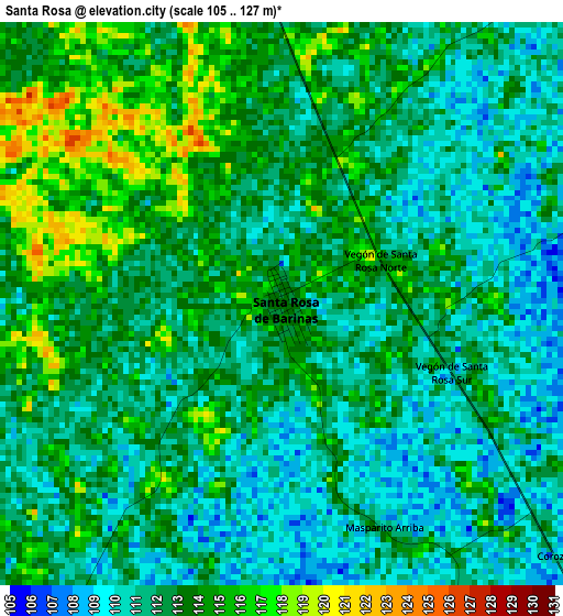
Below is the Elevation map of Santa Rosa, which displays elevation range with different colors. Scale of the first map is from 105 to 127 m (344 to 417 ft) with average elevation of 112.2 meters (=368 ft) [note 1]
These maps also provides idea of topography and contour of this city, they are displayed at different zoom levels. More info about maps, scale and edge coordinates you can find below images.
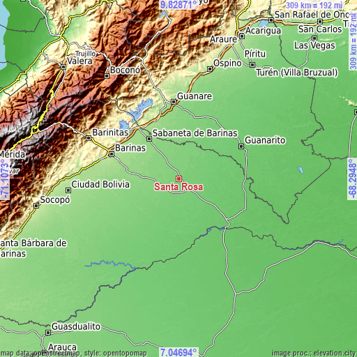
| \ | Map #1 | Topo.Map |
| Scale [m] | 105..127 m | × |
| Scale [ft] | 344..417 ft | × |
| Average | 112.2 m = 368 ft | × |
| Width | 9.67 km = 6 mi | 309.3 km = 192.2 mi |
| Height | 9.67 km = 6 mi | 309.3 km = 192.2 mi |
| ↑Max Latitude | 8.483797° | 9.82871° |
| Latitude at center | 8.44033° | 8.44033° |
| ↓Min Latitude | 8.396858° | 7.04694° |
| ← Min Longitude | -69.744995° | -71.1073° |
| Longitude center | -69.70105° | -69.70105° |
| →Max Longitude | -69.657105° | -68.2948° |
Nearby cities:
Cities around Santa Rosa sort by population:
• San Silvestre elevation 128 m
48.6 km,  247°
247°
• Obispos 159 m
48.1 km,  292°
292°
• Sabaneta 143 m
43.1 km,  323°
323°
• Torunos 142 m
42.3 km,  279°
279°
• Santa Lucía 102 m
38.6 km,  192°
192°
• Las Casitas del Vegon de Nutrias 90 m
38.5 km,  126°
126°
• El Real 132 m
32.5 km,  269°
269°
• Arauquita 124 m
30.2 km,  9°
9°
• Santa Inés 115 m
29.3 km,  227°
227°
• Dolores 100 m
22.7 km,  139°
139°
• Libertad 83 m
14.8 km,  148°
148°
• La Luz 119 m
14.4 km, 249°
Multilingual:
 En español:
Santa Rosa elevación 113 m.
 En France:
Santa Rosa élévation 113 m.
 Auf Deutsch:
Santa Rosa höhe über dem Meeresspiegel ist 113 m.

Sources and notes:
- [note 1] Map square and city borders are not equal. Map elevation data is calculated only from area inside that square.
- [src 1] Elevation data from geonames database provided with same terms of usage.
- [src 2] The elevation map of Santa Rosa is generated using elevation data from NASA's 3 arcsec (90m) resolution SRTM data.
- [src 3] Base (background) map © OpenStreetMap contributors tiles are generated by Geofabrik and OpenTopoMap.
Copyright & License:
This Santa Rosa Elevation Map is licensed under CC BY-SA. You may reuse any part from this page, if you give a proper credit by linking to this URL:
 More info on terms of use page.