Guanare elevation
Guanare (Portuguesa, Municipio Guanare), Venezuela elevation is 164 meters and Guanare elevation in feet is 538 ft above sea level [src 1]. Guanare is a seat of a first-order administrative division (feature code) with elevation that is 217 meters (712 ft) smaller than average city elevation in Venezuela.
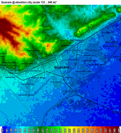
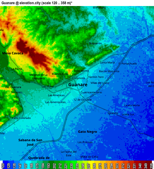
Below is the Elevation map of Guanare, which displays elevation range with different colors. Scale of the first map is from 133 to 348 m (436 to 1142 ft) with average elevation of 180 meters (=591 ft) [note 1]
These maps also provides idea of topography and contour of this city, they are displayed at different zoom levels. More info about maps, scale and edge coordinates you can find below images.
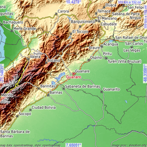
| \ | Map #1 | Map #2 | Topo.Map |
| Scale [m] | 133..348 m | 120..358 m | × |
| Scale [ft] | 436..1142 ft | 394..1175 ft | × |
| Average | 180 m = 591 ft | 175.5 m = 576 ft | × |
| Width | 9.65 km = 6 mi | 19.3 km = 12 mi | 308.8 km = 191.9 mi |
| Height | 9.65 km = 6 mi | 19.3 km = 12 mi | 308.8 km = 191.9 mi |
| ↑Max Latitude | 9.085227° | 9.128618° | 10.4278° |
| Latitude at center | 9.04183° | 9.04183° | 9.04183° |
| ↓Min Latitude | 8.998428° | 8.955021° | 7.65051° |
| ← Min Longitude | -69.786005° | -69.829951° | -71.14831° |
| Longitude center | -69.74206° | -69.74206° | -69.74206° |
| →Max Longitude | -69.698115° | -69.654169° | -68.33581° |
Nearby cities:
Cities around Guanare sort by population:
• Boconó elevation 1421 m
60.6 km,  292°
292°
• La Yuca 224 m
59.3 km,  234°
234°
• Campo Elías 1078 m
52.4 km,  318°
318°
• Barrancas 284 m
50.6 km, 233°
• Paraíso de Chabasquén 641 m
49 km,  332°
332°
• Biscucuy 639 m
44.2 km, 323°
• Ospino 184 m
42.4 km,  48°
48°
• Sabaneta 143 m
38.4 km,  213°
213°
• Arauquita 124 m
38.2 km,  165°
165°
• Veguitas 164 m
36.9 km, 228°
• Boconoito 190 m
34 km, 230°
• Papelón 109 m
32.9 km,  109°
109°
Multilingual:
 En español:
Guanare elevación 164 m.
 En France:
Guanare élévation 164 m.


Sources and notes:
- [note 1] Map square and city borders are not equal. Map elevation data is calculated only from area inside that square.
- [src 1] Elevation data from geonames database provided with same terms of usage.
- [src 2] The elevation map of Guanare is generated using elevation data from NASA's 3 arcsec (90m) resolution SRTM data.
- [src 3] Base (background) map © OpenStreetMap contributors tiles are generated by Geofabrik and OpenTopoMap.
Copyright & License:
This Guanare Elevation Map is licensed under CC BY-SA. You may reuse any part from this page, if you give a proper credit by linking to this URL:
 More info on terms of use page.