Higuerote elevation
Higuerote (Miranda, Municipio Brión), Venezuela elevation is 1 meters and Higuerote elevation in feet is 3 ft above sea level [src 1]. Higuerote is a seat of a second-order administrative division (feature code) with elevation that is 380 meters (1247 ft) smaller than average city elevation in Venezuela.
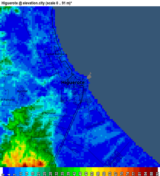
Below is the Elevation map of Higuerote, which displays elevation range with different colors. Scale of the first map is from 0 to 91 m (0 to 299 ft) with average elevation of 11.7 meters (=38 ft) [note 1]
These maps also provides idea of topography and contour of this city, they are displayed at different zoom levels. More info about maps, scale and edge coordinates you can find below images.
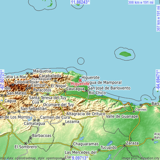
| \ | Map #1 | Topo.Map |
| Scale [m] | 0..91 m | × |
| Scale [ft] | 0..299 ft | × |
| Average | 11.7 m = 38 ft | × |
| Width | 9.61 km = 6 mi | 307.5 km = 191.1 mi |
| Height | 9.61 km = 6 mi | 307.5 km = 191.1 mi |
| ↑Max Latitude | 10.526079° | 11.86243° |
| Latitude at center | 10.48287° | 10.48287° |
| ↓Min Latitude | 10.439655° | 9.09713° |
| ← Min Longitude | -66.144905° | -67.50721° |
| Longitude center | -66.10096° | -66.10096° |
| →Max Longitude | -66.057015° | -64.69471° |
Nearby cities:
Cities around Higuerote sort by population:
• Santa Teresa del Tuy elevation 135 m
67.6 km,  245°
245°
• Guatire 368 m
48.3 km,  268°
268°
• Guarenas 523 m
56.7 km, 268°
• Caucagüito 707 m
69.6 km, 270°
• Naiguatá 18 m
71.3 km,  282°
282°
• Santa Lucía 175 m
64.3 km, 252°
• Cúpira 21 m
56.6 km,  129°
129°
• Caucagua 68 m
37.4 km,  233°
233°
• La Sabana 30 m
34.2 km,  296°
296°
• San José de Barlovento 6 m
23.5 km,  149°
149°
• Río Chico 8 m
22.7 km,  143°
143°
• Mamporal 23 m
13.5 km,  195°
195°
Multilingual:
 En español:
Higuerote elevación 1 m.
 En France:
Higuerote élévation 1 m.


Sources and notes:
- [note 1] Map square and city borders are not equal. Map elevation data is calculated only from area inside that square.
- [src 1] Elevation data from geonames database provided with same terms of usage.
- [src 2] The elevation map of Higuerote is generated using elevation data from NASA's 3 arcsec (90m) resolution SRTM data.
- [src 3] Base (background) map © OpenStreetMap contributors tiles are generated by Geofabrik and OpenTopoMap.
Copyright & License:
This Higuerote Elevation Map is licensed under CC BY-SA. You may reuse any part from this page, if you give a proper credit by linking to this URL:
 More info on terms of use page.