Cúpira elevation
Cúpira (Miranda, Municipio Pedro Gual), Venezuela elevation is 21 meters and Cúpira elevation in feet is 69 ft above sea level [src 1]. Cúpira is a seat of a second-order administrative division (feature code) with elevation that is 360 meters (1181 ft) smaller than average city elevation in Venezuela.
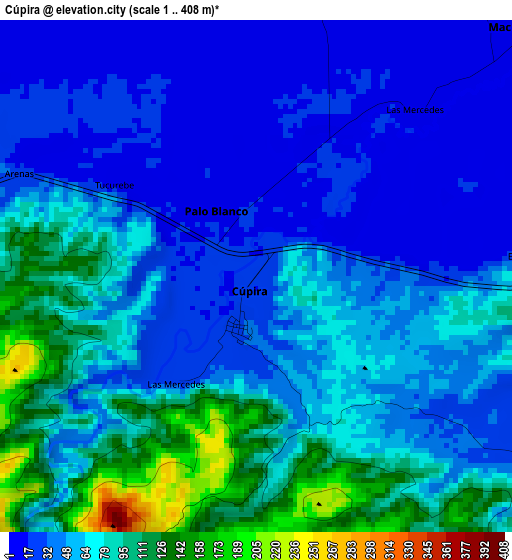
Below is the Elevation map of Cúpira, which displays elevation range with different colors. Scale of the first map is from 1 to 408 m (3 to 1339 ft) with average elevation of 59 meters (=194 ft) [note 1]
These maps also provides idea of topography and contour of this city, they are displayed at different zoom levels. More info about maps, scale and edge coordinates you can find below images.
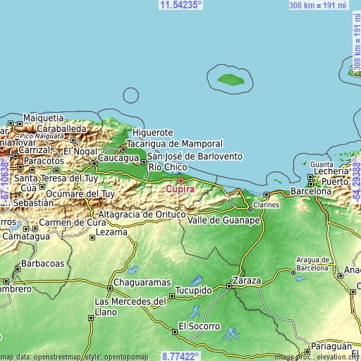
| \ | Map #1 | Topo.Map |
| Scale [m] | 1..408 m | × |
| Scale [ft] | 3..1339 ft | × |
| Average | 59 m = 194 ft | × |
| Width | 9.62 km = 6 mi | 307.8 km = 191.3 mi |
| Height | 9.62 km = 6 mi | 307.8 km = 191.3 mi |
| ↑Max Latitude | 10.204533° | 11.54235° |
| Latitude at center | 10.16128° | 10.16128° |
| ↓Min Latitude | 10.118021° | 8.77422° |
| ← Min Longitude | -65.744075° | -67.10638° |
| Longitude center | -65.70013° | -65.70013° |
| →Max Longitude | -65.656185° | -64.29388° |
Nearby cities:
Cities around Cúpira sort by population:
• Altagracia de Orituco elevation 352 m
81.8 km,  245°
245°
• Caucagua 68 m
75.2 km,  280°
280°
• Píritu 84 m
74.6 km,  100°
100°
• Puerto Píritu 10 m
73.5 km, 98°
• Clarines 29 m
63.5 km,  112°
112°
• Higuerote 1 m
56.6 km,  309°
309°
• Mamporal 23 m
52.6 km,  295°
295°
• San José de Guaribe 227 m
35.7 km,  200°
200°
• San José de Barlovento 6 m
35.4 km, 296°
• Río Chico 8 m
35.1 km, 300°
• Boca de Uchire 1 m
30.6 km, 96°
• Valle de Guanape 281 m
28.1 km,  174°
174°
Multilingual:
 En español:
Cúpira elevación 21 m.
 En France:
Cúpira élévation 21 m.


Sources and notes:
- [note 1] Map square and city borders are not equal. Map elevation data is calculated only from area inside that square.
- [src 1] Elevation data from geonames database provided with same terms of usage.
- [src 2] The elevation map of Cúpira is generated using elevation data from NASA's 3 arcsec (90m) resolution SRTM data.
- [src 3] Base (background) map © OpenStreetMap contributors tiles are generated by Geofabrik and OpenTopoMap.
Copyright & License:
This Cúpira Elevation Map is licensed under CC BY-SA. You may reuse any part from this page, if you give a proper credit by linking to this URL:
 More info on terms of use page.