Ortiz elevation
Ortiz (Guárico, Municipio Ortiz), Venezuela elevation is 188 meters and Ortiz elevation in feet is 617 ft above sea level [src 1]. Ortiz is a seat of a second-order administrative division (feature code) with elevation that is 193 meters (633 ft) smaller than average city elevation in Venezuela.
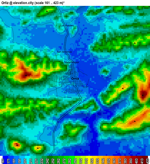
Below is the Elevation map of Ortiz, which displays elevation range with different colors. Scale of the first map is from 161 to 423 m (528 to 1388 ft) with average elevation of 224.8 meters (=738 ft) [note 1]
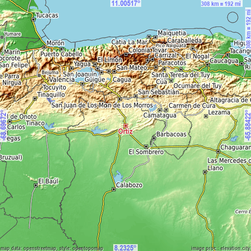
These maps also provides idea of topography and contour of this city, they are displayed at different zoom levels. More info about maps, scale and edge coordinates you can find below images.
| \ | Map #1 | Topo.Map |
| Scale [m] | 161..423 m | × |
| Scale [ft] | 528..1388 ft | × |
| Average | 224.8 m = 738 ft | × |
| Width | 9.63 km = 6 mi | 308.3 km = 191.6 mi |
| Height | 9.64 km = 6 mi | 308.3 km = 191.6 mi |
| ↑Max Latitude | 9.665004° | 11.00517° |
| Latitude at center | 9.62168° | 9.62168° |
| ↓Min Latitude | 9.57835° | 8.2325° |
| ← Min Longitude | -67.334415° | -68.69672° |
| Longitude center | -67.29047° | -67.29047° |
| →Max Longitude | -67.246525° | -65.88422° |
Nearby cities:
Cities around Ortiz sort by population:
• Palo Negro elevation 437 m
67.3 km,  335°
335°
• Cagua 465 m
65.5 km, 343°
• San Juan de los Morros 433 m
33 km,  347°
347°
• La Victoria 612 m
67.4 km,  356°
356°
• Villa de Cura 523 m
51.2 km,  334°
334°
• San Mateo 497 m
67.3 km, 347°
• Santa Cruz 450 m
66.6 km, 338°
• San Casimiro 490 m
51.9 km,  35°
35°
• Camatagua 250 m
46 km,  66°
66°
• Barbacoas 171 m
38.1 km,  114°
114°
• San Sebastián 359 m
37.8 km,  20°
20°
• El Sombrero 163 m
36.5 km,  135°
135°
Multilingual:
 En español:
Ortíz elevación 188 m.
 En France:
Ortiz élévation 188 m.


Sources and notes:
- [note 1] Map square and city borders are not equal. Map elevation data is calculated only from area inside that square.
- [src 1] Elevation data from geonames database provided with same terms of usage.
- [src 2] The elevation map of Ortiz is generated using elevation data from NASA's 3 arcsec (90m) resolution SRTM data.
- [src 3] Base (background) map © OpenStreetMap contributors tiles are generated by Geofabrik and OpenTopoMap.
Copyright & License:
This Ortiz Elevation Map is licensed under CC BY-SA. You may reuse any part from this page, if you give a proper credit by linking to this URL:
 More info on terms of use page.