Puerto Ayacucho elevation
Puerto Ayacucho (Amazonas, Municipio Autónomo Atures), Venezuela elevation is 84 meters and Puerto Ayacucho elevation in feet is 276 ft above sea level [src 1]. Puerto Ayacucho is a seat of a first-order administrative division (feature code) with elevation that is 297 meters (974 ft) smaller than average city elevation in Venezuela.
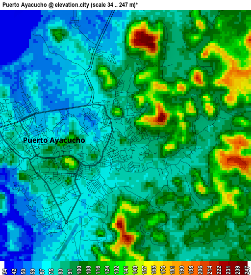
Below is the Elevation map of Puerto Ayacucho, which displays elevation range with different colors. Scale of the first map is from 34 to 247 m (112 to 810 ft) with average elevation of 92.3 meters (=303 ft) [note 1]
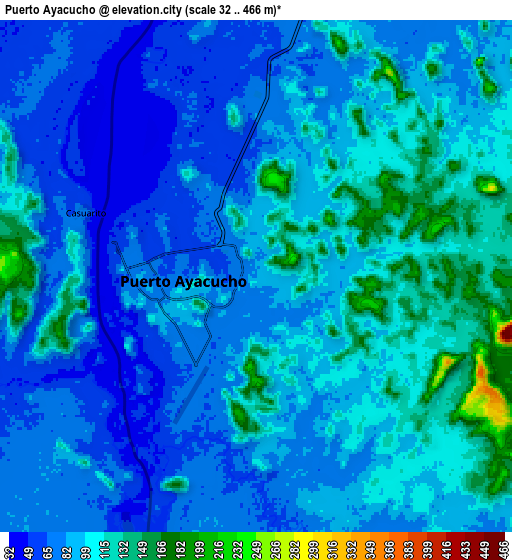
These maps also provides idea of topography and contour of this city, they are displayed at different zoom levels. More info about maps, scale and edge coordinates you can find below images.
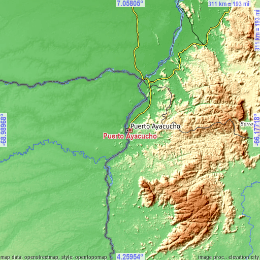
| \ | Map #1 | Map #2 | Topo.Map |
| Scale [m] | 34..247 m | 32..466 m | × |
| Scale [ft] | 112..810 ft | 105..1529 ft | × |
| Average | 92.3 m = 303 ft | 92.3 m = 303 ft | × |
| Width | 9.72 km = 6 mi | 19.45 km = 12.1 mi | 311.2 km = 193.4 mi |
| Height | 9.72 km = 6 mi | 19.45 km = 12.1 mi | 311.2 km = 193.4 mi |
| ↑Max Latitude | 5.704219° | 5.747945° | 7.05805° |
| Latitude at center | 5.66049° | 5.66049° | 5.66049° |
| ↓Min Latitude | 5.616757° | 5.573021° | 4.25954° |
| ← Min Longitude | -67.627375° | -67.671321° | -68.98968° |
| Longitude center | -67.58343° | -67.58343° | -67.58343° |
| →Max Longitude | -67.539485° | -67.495539° | -66.17718° |
Nearby cities:
Cities around Puerto Ayacucho sort by population:
• San Fernando de Apure elevation 51 m
248 km,  2°
2°
• San Antonio 70 m
272.8 km,  339°
339°
• Camaguán 60 m
272.1 km,  359°
359°
• Caicara del Orinoco 53 m
269.5 km,  35°
35°
• Elorza 94 m
262.7 km,  306°
306°
• Guayabal 56 m
261 km, 4°
• Achaguas 62 m
246 km, 343°
• Biruaca 51 m
243 km, 1°
• San Juan de Payara 53 m
220.8 km, 359°
• San Fernando de Atabapo 62 m
180 km,  184°
184°
• San Juan de Manapiare 1026 m
173.3 km,  102°
102°
• Isla Ratón 57 m
70.5 km,  201°
201°
Multilingual:
 En español:
Puerto Ayacucho elevación 84 m.
 En France:
Puerto Ayacucho élévation 84 m.
 Auf Deutsch:
Puerto Ayacucho höhe über dem Meeresspiegel ist 84 m.

Sources and notes:
- [note 1] Map square and city borders are not equal. Map elevation data is calculated only from area inside that square.
- [src 1] Elevation data from geonames database provided with same terms of usage.
- [src 2] The elevation map of Puerto Ayacucho is generated using elevation data from NASA's 3 arcsec (90m) resolution SRTM data.
- [src 3] Base (background) map © OpenStreetMap contributors tiles are generated by Geofabrik and OpenTopoMap.
Copyright & License:
This Puerto Ayacucho Elevation Map is licensed under CC BY-SA. You may reuse any part from this page, if you give a proper credit by linking to this URL:
 More info on terms of use page.