San Fernando de Atabapo elevation
San Fernando de Atabapo (Amazonas, Municipio Autónomo Atabapo), Venezuela elevation is 62 meters and San Fernando de Atabapo elevation in feet is 203 ft above sea level [src 1]. San Fernando de Atabapo is a seat of a second-order administrative division (feature code) with elevation that is 319 meters (1047 ft) smaller than average city elevation in Venezuela.
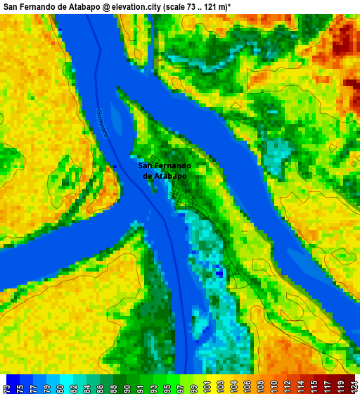
Below is the Elevation map of San Fernando de Atabapo, which displays elevation range with different colors. Scale of the first map is from 73 to 121 m (240 to 397 ft) with average elevation of 92.6 meters (=304 ft) [note 1]
These maps also provides idea of topography and contour of this city, they are displayed at different zoom levels. More info about maps, scale and edge coordinates you can find below images.
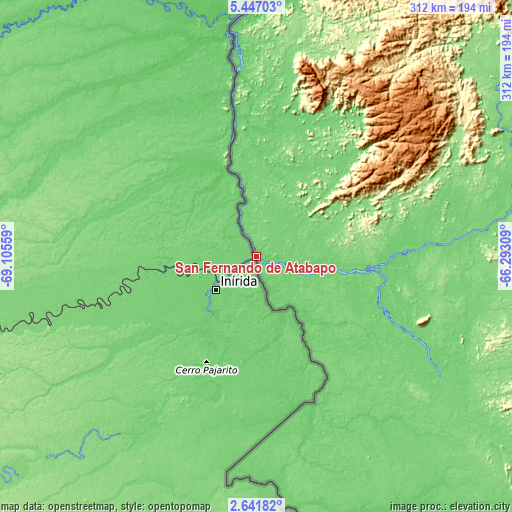
| \ | Map #1 | Topo.Map |
| Scale [m] | 73..121 m | × |
| Scale [ft] | 240..397 ft | × |
| Average | 92.6 m = 304 ft | × |
| Width | 9.75 km = 6.1 mi | 311.9 km = 193.8 mi |
| Height | 9.75 km = 6.1 mi | 311.9 km = 193.8 mi |
| ↑Max Latitude | 4.089475° | 5.44703° |
| Latitude at center | 4.04564° | 4.04564° |
| ↓Min Latitude | 4.001803° | 2.64182° |
| ← Min Longitude | -67.743285° | -69.10559° |
| Longitude center | -67.69934° | -67.69934° |
| →Max Longitude | -67.655395° | -66.29309° |
Nearby cities:
Cities around San Fernando de Atabapo sort by population:
• San Fernando de Apure elevation 51 m
427.9 km,  3°
3°
• Puerto Ayacucho 84 m
180 km, 4°
• Caicara del Orinoco 53 m
433.5 km,  22°
22°
• Biruaca 51 m
422.9 km, 2°
• Achaguas 62 m
419.2 km,  352°
352°
• San Juan de Payara 53 m
400.5 km, 1°
• Elorza 94 m
389.9 km,  329°
329°
• La Esmeralda 89 m
257.9 km,  112°
112°
• San Carlos de Río Negro 92 m
246.7 km,  163°
163°
• San Juan de Manapiare 1026 m
231.4 km,  52°
52°
• Maroa 93 m
148.3 km,  174°
174°
• Isla Ratón 57 m
114.4 km, 353°
Multilingual:
 En español:
San Fernando de Atabapo elevación 62 m.
 En France:
San Fernando de Atabapo élévation 62 m.
 Auf Deutsch:
San Fernando de Atabapo höhe über dem Meeresspiegel ist 62 m.
 На русском:
San Fernando de Atabapo высота над уровнем моря 62 м
Sources and notes:
- [note 1] Map square and city borders are not equal. Map elevation data is calculated only from area inside that square.
- [src 1] Elevation data from geonames database provided with same terms of usage.
- [src 2] The elevation map of San Fernando de Atabapo is generated using elevation data from NASA's 3 arcsec (90m) resolution SRTM data.
- [src 3] Base (background) map © OpenStreetMap contributors tiles are generated by Geofabrik and OpenTopoMap.
Copyright & License:
This San Fernando de Atabapo Elevation Map is licensed under CC BY-SA. You may reuse any part from this page, if you give a proper credit by linking to this URL:
 More info on terms of use page.