Elorza elevation
Elorza (Apure, Municipio Rómulo Gallegos), Venezuela elevation is 94 meters and Elorza elevation in feet is 308 ft above sea level [src 1]. Elorza is a seat of a second-order administrative division (feature code) with elevation that is 287 meters (942 ft) smaller than average city elevation in Venezuela.
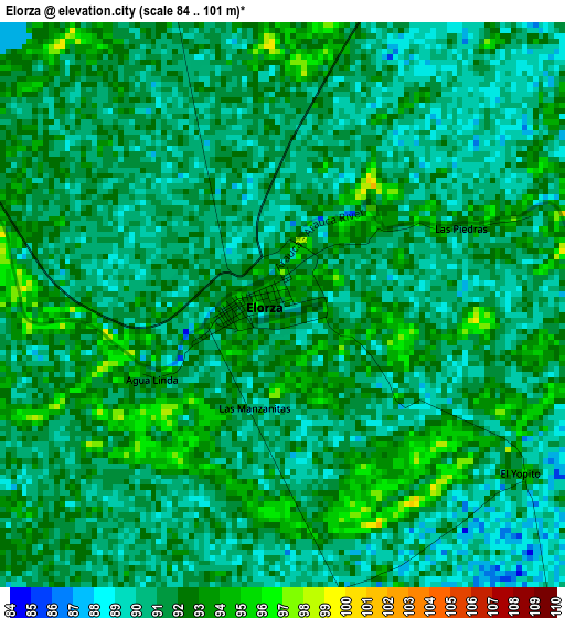
Below is the Elevation map of Elorza, which displays elevation range with different colors. Scale of the first map is from 84 to 101 m (276 to 331 ft) with average elevation of 91.1 meters (=299 ft) [note 1]
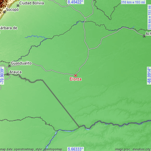
These maps also provides idea of topography and contour of this city, they are displayed at different zoom levels. More info about maps, scale and edge coordinates you can find below images.
| \ | Map #1 | Topo.Map |
| Scale [m] | 84..101 m | × |
| Scale [ft] | 276..331 ft | × |
| Average | 91.1 m = 299 ft | × |
| Width | 9.7 km = 6 mi | 310.3 km = 192.8 mi |
| Height | 9.7 km = 6 mi | 310.3 km = 192.8 mi |
| ↑Max Latitude | 7.10449° | 8.45422° |
| Latitude at center | 7.06088° | 7.06088° |
| ↓Min Latitude | 7.017266° | 5.66333° |
| ← Min Longitude | -69.541595° | -70.9039° |
| Longitude center | -69.49765° | -69.49765° |
| →Max Longitude | -69.453705° | -68.0914° |
Nearby cities:
Cities around Elorza sort by population:
• Guasdualito elevation 130 m
137.7 km,  278°
278°
• Libertad 83 m
141.6 km,  354°
354°
• Santa Inés 115 m
140.7 km,  341°
341°
• Dolores 100 m
136.5 km,  356°
356°
• Las Casitas del Vegon de Nutrias 90 m
131.1 km,  3°
3°
• San Rafael de Canaguá 109 m
121.3 km,  332°
332°
• Maporal 115 m
120.7 km,  302°
302°
• Santa Lucía 102 m
119.8 km, 345°
• Ciudad De Nutrias 84 m
116.9 km,  10°
10°
• Santa Catalina 72 m
115.3 km,  33°
33°
• Puerto de Nutrias 83 m
114.6 km, 10°
• Bruzual 85 m
111.5 km, 9°
Multilingual:
 En español:
Elorza elevación 94 m.
 En France:
Elorza élévation 94 m.


Sources and notes:
- [note 1] Map square and city borders are not equal. Map elevation data is calculated only from area inside that square.
- [src 1] Elevation data from geonames database provided with same terms of usage.
- [src 2] The elevation map of Elorza is generated using elevation data from NASA's 3 arcsec (90m) resolution SRTM data.
- [src 3] Base (background) map © OpenStreetMap contributors tiles are generated by Geofabrik and OpenTopoMap.
Copyright & License:
This Elorza Elevation Map is licensed under CC BY-SA. You may reuse any part from this page, if you give a proper credit by linking to this URL:
 More info on terms of use page.