Santo Domingo elevation
Santo Domingo (Mérida, Municipio Cardenal Quintero), Venezuela elevation is 2151 meters and Santo Domingo elevation in feet is 7057 ft above sea level [src 1]. Santo Domingo is a seat of a second-order administrative division (feature code) with elevation that is 1770 meters (5807 ft) bigger than average city elevation in Venezuela.
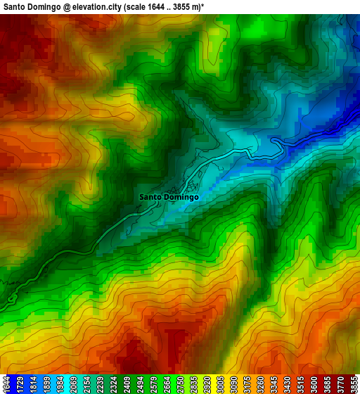
Below is the Elevation map of Santo Domingo, which displays elevation range with different colors. Scale of the first map is from 1644 to 3855 m (5394 to 12648 ft) with average elevation of 2761.4 meters (=9060 ft) [note 1]
These maps also provides idea of topography and contour of this city, they are displayed at different zoom levels. More info about maps, scale and edge coordinates you can find below images.
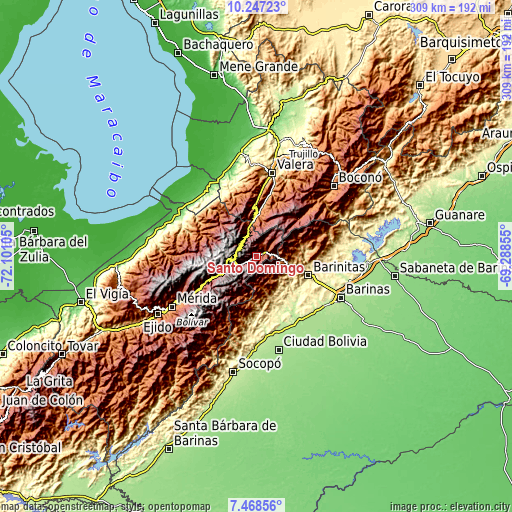
| \ | Map #1 | Topo.Map |
| Scale [m] | 1644..3855 m | × |
| Scale [ft] | 5394..12648 ft | × |
| Average | 2761.4 m = 9060 ft | × |
| Width | 9.66 km = 6 mi | 309 km = 192 mi |
| Height | 9.66 km = 6 mi | 309 km = 192 mi |
| ↑Max Latitude | 8.903938° | 10.24723° |
| Latitude at center | 8.86052° | 8.86052° |
| ↓Min Latitude | 8.817097° | 7.46856° |
| ← Min Longitude | -70.738745° | -72.10105° |
| Longitude center | -70.6948° | -70.6948° |
| →Max Longitude | -70.650855° | -69.28855° |
Nearby cities:
Cities around Santo Domingo sort by population:
• Barinitas elevation 463 m
33 km,  109°
109°
• La Mula 222 m
47.7 km,  132°
132°
• Masparrito 1062 m
46 km,  70°
70°
• Quebrada Seca 308 m
44.9 km, 113°
• Torondoy 1051 m
40.1 km,  298°
298°
• Monte Carmelo 1161 m
38.7 km,  340°
340°
• La Quebrada 1771 m
35.2 km,  21°
21°
• Calderas 908 m
27.8 km,  77°
77°
• Mucuchíes 2986 m
27.6 km,  243°
243°
• Altamira 816 m
21.5 km,  100°
100°
• Timotes 2001 m
14.4 km, 340°
• Pueblo Llano 2161 m
7.2 km,  32°
32°
Multilingual:
 En español:
Santo Domingo elevación 2151 m.
 En France:
Santo Domingo élévation 2151 m.
 Auf Deutsch:
Santo Domingo höhe über dem Meeresspiegel ist 2151 m.

Sources and notes:
- [note 1] Map square and city borders are not equal. Map elevation data is calculated only from area inside that square.
- [src 1] Elevation data from geonames database provided with same terms of usage.
- [src 2] The elevation map of Santo Domingo is generated using elevation data from NASA's 3 arcsec (90m) resolution SRTM data.
- [src 3] Base (background) map © OpenStreetMap contributors tiles are generated by Geofabrik and OpenTopoMap.
Copyright & License:
This Santo Domingo Elevation Map is licensed under CC BY-SA. You may reuse any part from this page, if you give a proper credit by linking to this URL:
 More info on terms of use page.