Torondoy elevation
Torondoy (Mérida, Municipio Justo Briceño), Venezuela elevation is 1051 meters and Torondoy elevation in feet is 3448 ft above sea level [src 1]. Torondoy is a seat of a second-order administrative division (feature code) with elevation that is 670 meters (2198 ft) bigger than average city elevation in Venezuela.
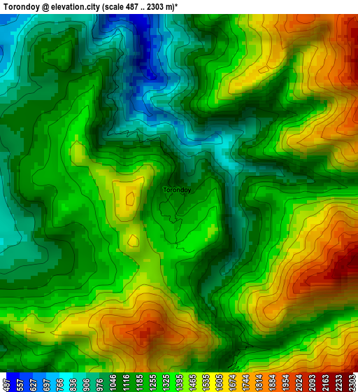
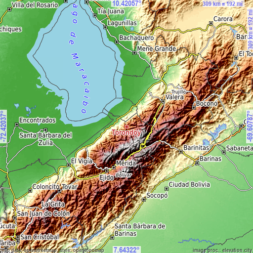
Below is the Elevation map of Torondoy, which displays elevation range with different colors. Scale of the first map is from 487 to 2303 m (1598 to 7556 ft) with average elevation of 1288.8 meters (=4228 ft) [note 1]
These maps also provides idea of topography and contour of this city, they are displayed at different zoom levels. More info about maps, scale and edge coordinates you can find below images.
| \ | Map #1 | Topo.Map |
| Scale [m] | 487..2303 m | × |
| Scale [ft] | 1598..7556 ft | × |
| Average | 1288.8 m = 4228 ft | × |
| Width | 9.65 km = 6 mi | 308.8 km = 191.9 mi |
| Height | 9.65 km = 6 mi | 308.8 km = 191.9 mi |
| ↑Max Latitude | 9.077967° | 10.42057° |
| Latitude at center | 9.03457° | 9.03457° |
| ↓Min Latitude | 8.991167° | 7.64322° |
| ← Min Longitude | -71.058065° | -72.42037° |
| Longitude center | -71.01412° | -71.01412° |
| →Max Longitude | -70.970175° | -69.60787° |
Nearby cities:
Cities around Torondoy sort by population:
• Escuque elevation 1019 m
47.6 km,  52°
52°
• Sabana Grande 191 m
47.2 km,  30°
30°
• Tabay 1687 m
45.3 km,  188°
188°
• Pueblo Llano 2161 m
41.2 km,  108°
108°
• Santo Domingo 2151 m
40.1 km,  118°
118°
• Mucuchíes 2986 m
33.4 km,  161°
161°
• Timotes 2001 m
30.7 km,  100°
100°
• Tucaní 169 m
29.3 km,  255°
255°
• Bobures 3 m
29 km,  322°
322°
• Monte Carmelo 1161 m
28 km, 52°
• Arapuey 54 m
25.9 km,  15°
15°
• Nueva Bolivia 116 m
14.5 km, 324°
Multilingual:
 En español:
Torondoy elevación 1051 m.
 En France:
Torondoy élévation 1051 m.
 Auf Deutsch:
Torondoy höhe über dem Meeresspiegel ist 1051 m.

Sources and notes:
- [note 1] Map square and city borders are not equal. Map elevation data is calculated only from area inside that square.
- [src 1] Elevation data from geonames database provided with same terms of usage.
- [src 2] The elevation map of Torondoy is generated using elevation data from NASA's 3 arcsec (90m) resolution SRTM data.
- [src 3] Base (background) map © OpenStreetMap contributors tiles are generated by Geofabrik and OpenTopoMap.
Copyright & License:
This Torondoy Elevation Map is licensed under CC BY-SA. You may reuse any part from this page, if you give a proper credit by linking to this URL:
 More info on terms of use page.