Tucupita elevation
Tucupita (Delta Amacuro, Municipio Tucupita), Venezuela elevation is 9 meters and Tucupita elevation in feet is 30 ft above sea level [src 1]. Tucupita is a seat of a first-order administrative division (feature code) with elevation that is 372 meters (1220 ft) smaller than average city elevation in Venezuela.
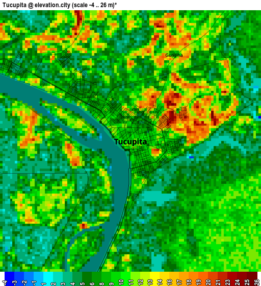
Below is the Elevation map of Tucupita, which displays elevation range with different colors. Scale of the first map is from -4 to 26 m (-13 to 85 ft) with average elevation of 8.2 meters (=27 ft) [note 1]
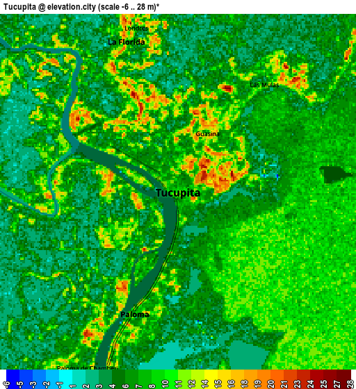
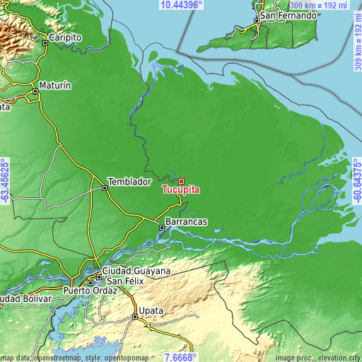
These maps also provides idea of topography and contour of this city, they are displayed at different zoom levels. More info about maps, scale and edge coordinates you can find below images.
| \ | Map #1 | Map #2 | Topo.Map |
| Scale [m] | -4..26 m | -6..28 m | × |
| Scale [ft] | -13..85 ft | -20..92 ft | × |
| Average | 8.2 m = 27 ft | 7.2 m = 24 ft | × |
| Width | 9.65 km = 6 mi | 19.3 km = 12 mi | 308.8 km = 191.9 mi |
| Height | 9.65 km = 6 mi | 19.3 km = 12 mi | 308.8 km = 191.9 mi |
| ↑Max Latitude | 9.101455° | 9.144844° | 10.44396° |
| Latitude at center | 9.05806° | 9.05806° | 9.05806° |
| ↓Min Latitude | 9.01466° | 8.971255° | 7.6668° |
| ← Min Longitude | -62.093945° | -62.137891° | -63.45625° |
| Longitude center | -62.05° | -62.05° | -62.05° |
| →Max Longitude | -62.006055° | -61.962109° | -60.64375° |
Nearby cities:
Cities around Tucupita sort by population:
• Ciudad Guayana elevation 103 m
102 km,  219°
219°
• Maturín 71 m
145.9 km,  301°
301°
• Upata 322 m
122.3 km,  198°
198°
• Quiriquire 73 m
164.2 km,  308°
308°
• Curiapo 6 m
127.2 km,  114°
114°
• El Palmar 387 m
117.5 km,  172°
172°
• El Palmer 307 m
115.4 km, 170°
• Pedernales 13 m
103.9 km,  347°
347°
• Sierra Imataca 5 m
86.2 km,  211°
211°
• Temblador 28 m
65.6 km,  264°
264°
• Barrancas 1 m
43.1 km, 201°
• Uracoa 4 m
33.9 km, 257°
Multilingual:
 En español:
Tucupita elevación 9 m.
 En France:
Tucupita élévation 9 m.


Sources and notes:
- [note 1] Map square and city borders are not equal. Map elevation data is calculated only from area inside that square.
- [src 1] Elevation data from geonames database provided with same terms of usage.
- [src 2] The elevation map of Tucupita is generated using elevation data from NASA's 3 arcsec (90m) resolution SRTM data.
- [src 3] Base (background) map © OpenStreetMap contributors tiles are generated by Geofabrik and OpenTopoMap.
Copyright & License:
This Tucupita Elevation Map is licensed under CC BY-SA. You may reuse any part from this page, if you give a proper credit by linking to this URL:
 More info on terms of use page.