Ciudad Guayana elevation
Ciudad Guayana (Bolívar, Municipio Caroní), Venezuela elevation is 103 meters and Ciudad Guayana elevation in feet is 338 ft above sea level [src 1]. Ciudad Guayana is a seat of a second-order administrative division (feature code) with elevation that is 278 meters (912 ft) smaller than average city elevation in Venezuela.
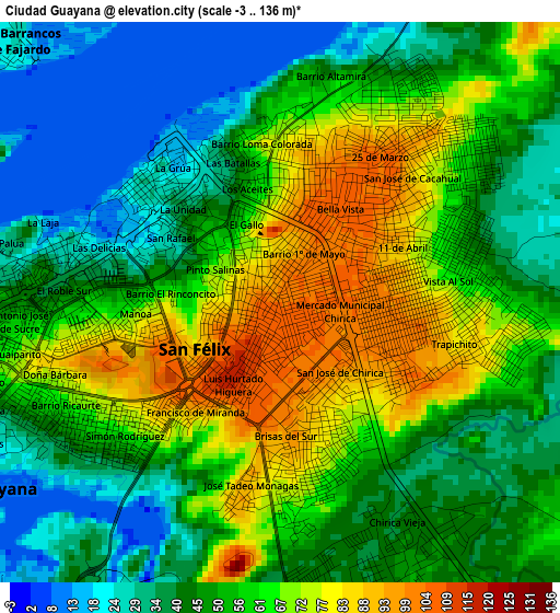
Below is the Elevation map of Ciudad Guayana, which displays elevation range with different colors. Scale of the first map is from -3 to 136 m (-10 to 446 ft) with average elevation of 53.4 meters (=175 ft) [note 1]
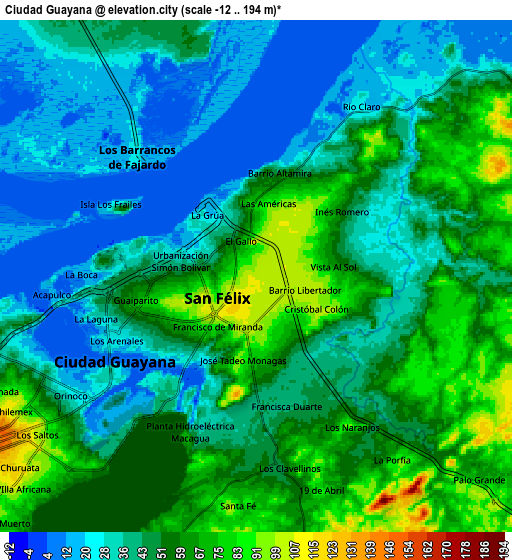
These maps also provides idea of topography and contour of this city, they are displayed at different zoom levels. More info about maps, scale and edge coordinates you can find below images.
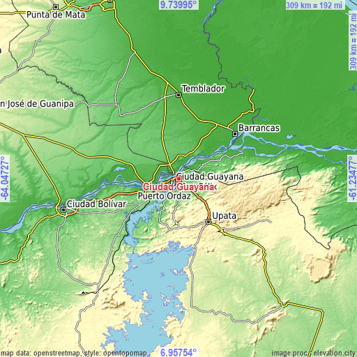
| \ | Map #1 | Map #2 | Topo.Map |
| Scale [m] | -3..136 m | -12..194 m | × |
| Scale [ft] | -10..446 ft | -39..636 ft | × |
| Average | 53.4 m = 175 ft | 46.7 m = 153 ft | × |
| Width | 9.67 km = 6 mi | 19.34 km = 12 mi | 309.4 km = 192.3 mi |
| Height | 9.67 km = 6 mi | 19.34 km = 12 mi | 309.4 km = 192.3 mi |
| ↑Max Latitude | 8.394697° | 8.438169° | 9.73995° |
| Latitude at center | 8.35122° | 8.35122° | 8.35122° |
| ↓Min Latitude | 8.307738° | 8.264252° | 6.95754° |
| ← Min Longitude | -62.684965° | -62.728911° | -64.04727° |
| Longitude center | -62.64102° | -62.64102° | -62.64102° |
| →Max Longitude | -62.597075° | -62.553129° | -61.23477° |
Nearby cities:
Cities around Ciudad Guayana sort by population:
• Ciudad Bolívar elevation 45 m
102 km,  256°
256°
• Upata 322 m
45.4 km,  145°
145°
• Tucupita 9 m
102 km,  39°
39°
• Guasipati 198 m
127.2 km,  139°
139°
• Ciudad Piar 305 m
124.8 km,  216°
216°
• Soledad 34 m
103.9 km, 258°
• El Palmer 307 m
90.6 km,  112°
112°
• El Palmar 387 m
89.2 km,  115°
115°
• Uracoa 4 m
78.2 km,  23°
23°
• Temblador 28 m
72.7 km,  359°
359°
• Barrancas 1 m
62.3 km,  51°
51°
• Sierra Imataca 5 m
21.1 km,  77°
77°
Multilingual:
 En español:
Ciudad Guayana elevación 103 m.
 En France:
Ciudad Guayana élévation 103 m.
 Auf Deutsch:
Ciudad Guayana höhe über dem Meeresspiegel ist 103 m.

Sources and notes:
- [note 1] Map square and city borders are not equal. Map elevation data is calculated only from area inside that square.
- [src 1] Elevation data from geonames database provided with same terms of usage.
- [src 2] The elevation map of Ciudad Guayana is generated using elevation data from NASA's 3 arcsec (90m) resolution SRTM data.
- [src 3] Base (background) map © OpenStreetMap contributors tiles are generated by Geofabrik and OpenTopoMap.
Copyright & License:
This Ciudad Guayana Elevation Map is licensed under CC BY-SA. You may reuse any part from this page, if you give a proper credit by linking to this URL:
 More info on terms of use page.