Maturín elevation
Maturín (Monagas, Municipio Maturín), Venezuela elevation is 71 meters and Maturín elevation in feet is 233 ft above sea level [src 1]. Maturín is a seat of a first-order administrative division (feature code) with elevation that is 310 meters (1017 ft) smaller than average city elevation in Venezuela.
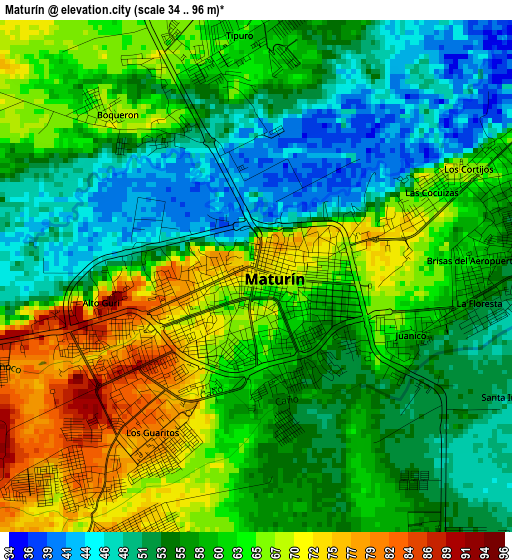
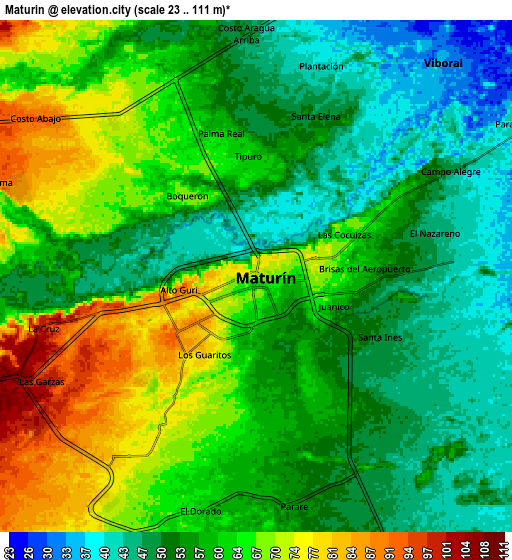
Below is the Elevation map of Maturín, which displays elevation range with different colors. Scale of the first map is from 34 to 96 m (112 to 315 ft) with average elevation of 59.1 meters (=194 ft) [note 1]
These maps also provides idea of topography and contour of this city, they are displayed at different zoom levels. More info about maps, scale and edge coordinates you can find below images.
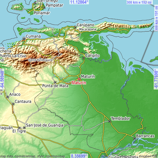
| \ | Map #1 | Map #2 | Topo.Map |
| Scale [m] | 34..96 m | 23..111 m | × |
| Scale [ft] | 112..315 ft | 75..364 ft | × |
| Average | 59.1 m = 194 ft | 58.5 m = 192 ft | × |
| Width | 9.63 km = 6 mi | 19.26 km = 12 mi | 308.2 km = 191.5 mi |
| Height | 9.63 km = 6 mi | 19.26 km = 12 mi | 308.2 km = 191.5 mi |
| ↑Max Latitude | 9.788998° | 9.832301° | 11.12864° |
| Latitude at center | 9.74569° | 9.74569° | 9.74569° |
| ↓Min Latitude | 9.702376° | 9.659057° | 8.35699° |
| ← Min Longitude | -63.227175° | -63.271121° | -64.58948° |
| Longitude center | -63.18323° | -63.18323° | -63.18323° |
| →Max Longitude | -63.139285° | -63.095339° | -61.77698° |
Nearby cities:
Cities around Maturín sort by population:
• Tunapuy elevation 48 m
92.6 km,  5°
5°
• El Pilar 23 m
89.2 km,  2°
2°
• Casanay 78 m
88.1 km,  343°
343°
• San Antonio 474 m
72.5 km,  304°
304°
• Aguasay 218 m
69.8 km,  239°
239°
• Caripe 943 m
58.9 km,  323°
323°
• Santa Bárbara 159 m
49.2 km,  251°
251°
• Caicara 187 m
47.8 km,  279°
279°
• Punta de Mata 246 m
47.1 km,  262°
262°
• Caripito 43 m
41.7 km, 12°
• Aragua 240 m
41.6 km,  306°
306°
• Quiriquire 73 m
26.3 km,  351°
351°
Multilingual:
 En español:
Maturín elevación 71 m.
 En France:
Maturín élévation 71 m.


Sources and notes:
- [note 1] Map square and city borders are not equal. Map elevation data is calculated only from area inside that square.
- [src 1] Elevation data from geonames database provided with same terms of usage.
- [src 2] The elevation map of Maturín is generated using elevation data from NASA's 3 arcsec (90m) resolution SRTM data.
- [src 3] Base (background) map © OpenStreetMap contributors tiles are generated by Geofabrik and OpenTopoMap.
Copyright & License:
This Maturín Elevation Map is licensed under CC BY-SA. You may reuse any part from this page, if you give a proper credit by linking to this URL:
 More info on terms of use page.