Bulung’ur elevation
Bulung’ur (Samarqand), Uzbekistan elevation is 758 meters and Bulung’ur elevation in feet is 2487 ft above sea level [src 1]. Bulung’ur is a populated place (feature code) with elevation that is 329 meters (1079 ft) bigger than average city elevation in Uzbekistan.
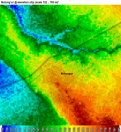
Below is the Elevation map of Bulung’ur, which displays elevation range with different colors. Scale of the first map is from 722 to 783 m (2369 to 2569 ft) with average elevation of 751.2 meters (=2465 ft) [note 1]
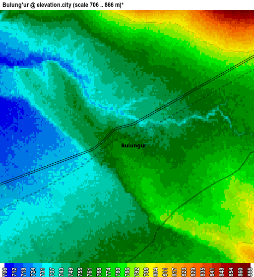
These maps also provides idea of topography and contour of this city, they are displayed at different zoom levels. More info about maps, scale and edge coordinates you can find below images.
| \ | Map #1 | Map #2 | Topo.Map |
| Scale [m] | 722..783 m | 706..866 m | × |
| Scale [ft] | 2369..2569 ft | 2316..2841 ft | × |
| Average | 751.2 m = 2465 ft | 757.4 m = 2485 ft | × |
| Width | 7.51 km = 4.7 mi | 15.02 km = 9.3 mi | 240.4 km = 149.4 mi |
| Height | 7.51 km = 4.7 mi | 15.02 km = 9.3 mi | 240.4 km = 149.4 mi |
| ↑Max Latitude | 39.798491° | 39.832246° | 40.83717° |
| Latitude at center | 39.76472° | 39.76472° | 39.76472° |
| ↓Min Latitude | 39.730932° | 39.697127° | 38.6753° |
| ← Min Longitude | 67.227445° | 67.183499° | 65.86514° |
| Longitude center | 67.27139° | 67.27139° | 67.27139° |
| →Max Longitude | 67.315335° | 67.359281° | 68.67764° |
Nearby cities:
Cities around Bulung’ur sort by population:
• Samarkand elevation 719 m
29.4 km,  245°
245°
• Jizzax 382 m
62.4 km,  51°
51°
• Urgut 1013 m
40.4 km,  183°
183°
• Kitob 622 m
84.5 km,  206°
206°
• Paxtakor 307 m
84.4 km,  43°
43°
• Juma 626 m
52.2 km,  264°
264°
• Chelak 605 m
39.1 km,  296°
296°
• Jomboy 708 m
16.9 km,  244°
244°
• Charxin 651 m
43.7 km, 260°
• Ishtixon 516 m
70.7 km,  288°
288°
• Daxbet 644 m
30.7 km,  269°
269°
• Kitob Shahri 644 m
79.1 km, 205°
Multilingual:
 En español:
Bulung’ur elevación 758 m.
 En France:
Bulung’ur élévation 758 m.
 Auf Deutsch:
Bulung’ur höhe über dem Meeresspiegel ist 758 m.

Sources and notes:
- [note 1] Map square and city borders are not equal. Map elevation data is calculated only from area inside that square.
- [src 1] Elevation data from geonames database provided with same terms of usage.
- [src 2] The elevation map of Bulung’ur is generated using elevation data from NASA's 3 arcsec (90m) resolution SRTM data.
- [src 3] Base (background) map © OpenStreetMap contributors tiles are generated by Geofabrik and OpenTopoMap.
Copyright & License:
This Bulung’ur Elevation Map is licensed under CC BY-SA. You may reuse any part from this page, if you give a proper credit by linking to this URL:
 More info on terms of use page.