Kitob elevation
Kitob (Qashqadaryo), Uzbekistan elevation is 622 meters and Kitob elevation in feet is 2041 ft above sea level [src 1]. Kitob is a populated place (feature code) with elevation that is 193 meters (633 ft) bigger than average city elevation in Uzbekistan.
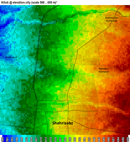
Below is the Elevation map of Kitob, which displays elevation range with different colors. Scale of the first map is from 588 to 659 m (1929 to 2162 ft) with average elevation of 623.5 meters (=2046 ft) [note 1]
These maps also provides idea of topography and contour of this city, they are displayed at different zoom levels. More info about maps, scale and edge coordinates you can find below images.

| \ | Map #1 | Map #2 | Topo.Map |
| Scale [m] | 588..659 m | 563..711 m | × |
| Scale [ft] | 1929..2162 ft | 1847..2333 ft | × |
| Average | 623.5 m = 2046 ft | 627.8 m = 2060 ft | × |
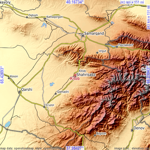
| Width | 7.59 km = 4.7 mi | 15.17 km = 9.4 mi | 242.7 km = 150.8 mi |
| Height | 7.59 km = 4.7 mi | 15.17 km = 9.4 mi | 242.7 km = 150.8 mi |
| ↑Max Latitude | 39.118353° | 39.152439° | 40.16734° |
| Latitude at center | 39.08425° | 39.08425° | 39.08425° |
| ↓Min Latitude | 39.050131° | 39.015995° | 37.98427° |
| ← Min Longitude | 66.789235° | 66.745289° | 65.42693° |
| Longitude center | 66.83318° | 66.83318° | 66.83318° |
| →Max Longitude | 66.877125° | 66.921071° | 68.23943° |
Nearby cities:
Cities around Kitob sort by population:
• Samarkand elevation 719 m
64.3 km,  9°
9°
• Shahrisabz 631 m
2.9 km,  178°
178°
• Urgut 1013 m
50 km,  44°
44°
• Juma 626 m
71.7 km,  348°
348°
• Chiroqchi 524 m
23.2 km,  255°
255°
• Jomboy 708 m
71.9 km,  18°
18°
• Charxin 651 m
68.3 km,  355°
355°
• Qamashi Shahri 520 m
43.4 km,  227°
227°
• Chiroqchi Shahri 529 m
22.7 km,  253°
253°
• Yakkabog‘ Shahri 587 m
17.3 km, 226°
• Kitob Shahri 644 m
5.6 km, 40°
• Shahrisabz Shahri 622 m
3.7 km,  196°
196°
Multilingual:
 En español:
Kitob elevación 622 m.
 En France:
Kitob élévation 622 m.


Sources and notes:
- [note 1] Map square and city borders are not equal. Map elevation data is calculated only from area inside that square.
- [src 1] Elevation data from geonames database provided with same terms of usage.
- [src 2] The elevation map of Kitob is generated using elevation data from NASA's 3 arcsec (90m) resolution SRTM data.
- [src 3] Base (background) map © OpenStreetMap contributors tiles are generated by Geofabrik and OpenTopoMap.
Copyright & License:
This Kitob Elevation Map is licensed under CC BY-SA. You may reuse any part from this page, if you give a proper credit by linking to this URL:
 More info on terms of use page.