Charxin elevation
Charxin (Samarqand), Uzbekistan elevation is 651 meters and Charxin elevation in feet is 2136 ft above sea level [src 1]. Charxin is a populated place (feature code) with elevation that is 222 meters (728 ft) bigger than average city elevation in Uzbekistan.
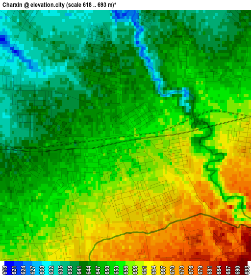
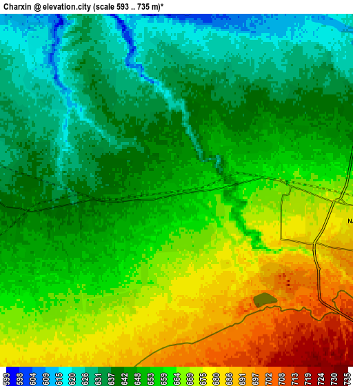
Below is the Elevation map of Charxin, which displays elevation range with different colors. Scale of the first map is from 618 to 693 m (2028 to 2274 ft) with average elevation of 651.5 meters (=2137 ft) [note 1]
These maps also provides idea of topography and contour of this city, they are displayed at different zoom levels. More info about maps, scale and edge coordinates you can find below images.
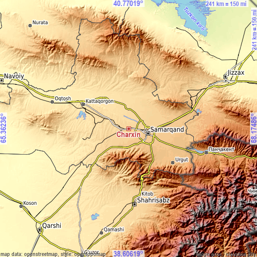
| \ | Map #1 | Map #2 | Topo.Map |
| Scale [m] | 618..693 m | 593..735 m | × |
| Scale [ft] | 2028..2274 ft | 1946..2411 ft | × |
| Average | 651.5 m = 2137 ft | 653.9 m = 2145 ft | × |
| Width | 7.52 km = 4.7 mi | 15.04 km = 9.3 mi | 240.6 km = 149.5 mi |
| Height | 7.52 km = 4.7 mi | 15.04 km = 9.3 mi | 240.6 km = 149.5 mi |
| ↑Max Latitude | 39.730475° | 39.764263° | 40.77019° |
| Latitude at center | 39.69667° | 39.69667° | 39.69667° |
| ↓Min Latitude | 39.662849° | 39.629011° | 38.60619° |
| ← Min Longitude | 66.724665° | 66.680719° | 65.36236° |
| Longitude center | 66.76861° | 66.76861° | 66.76861° |
| →Max Longitude | 66.812555° | 66.856501° | 68.17486° |
Nearby cities:
Cities around Charxin sort by population:
• Samarkand elevation 719 m
17 km,  106°
106°
• Kattaqo‘rg‘on 486 m
49.2 km,  297°
297°
• Urgut 1013 m
52.2 km,  128°
128°
• Kitob 622 m
68.3 km,  175°
175°
• Bulung’ur 758 m
43.7 km,  80°
80°
• Payshanba 468 m
57.1 km,  307°
307°
• Juma 626 m
9.2 km,  283°
283°
• Chelak 605 m
26.1 km,  17°
17°
• Jomboy 708 m
27.8 km,  89°
89°
• Ishtixon 516 m
38.5 km,  321°
321°
• Daxbet 644 m
14.4 km,  58°
58°
• Kitob Shahri 644 m
64.5 km,  171°
171°
Multilingual:
 En español:
Charxin elevación 651 m.
 En France:
Charxin élévation 651 m.


Sources and notes:
- [note 1] Map square and city borders are not equal. Map elevation data is calculated only from area inside that square.
- [src 1] Elevation data from geonames database provided with same terms of usage.
- [src 2] The elevation map of Charxin is generated using elevation data from NASA's 3 arcsec (90m) resolution SRTM data.
- [src 3] Base (background) map © OpenStreetMap contributors tiles are generated by Geofabrik and OpenTopoMap.
Copyright & License:
This Charxin Elevation Map is licensed under CC BY-SA. You may reuse any part from this page, if you give a proper credit by linking to this URL:
 More info on terms of use page.