Bella Unión elevation
Bella Unión (Artigas, Bella Union), Uruguay elevation is 53 meters and Bella Unión elevation in feet is 174 ft above sea level [src 1]. Bella Unión is a populated place (feature code) with elevation that is 18 meters (59 ft) smaller than average city elevation in Uruguay.
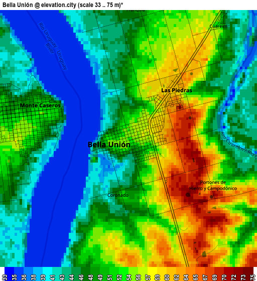
Below is the Elevation map of Bella Unión, which displays elevation range with different colors. Scale of the first map is from 33 to 75 m (108 to 246 ft) with average elevation of 48.9 meters (=160 ft) [note 1]
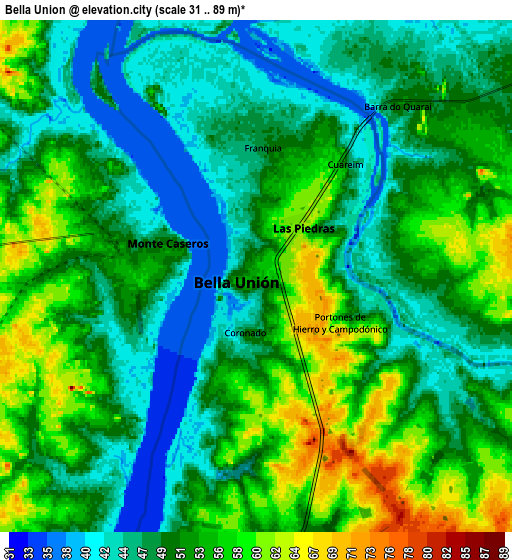
These maps also provides idea of topography and contour of this city, they are displayed at different zoom levels. More info about maps, scale and edge coordinates you can find below images.
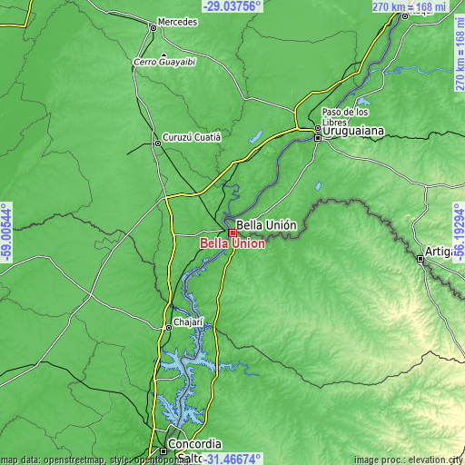
| \ | Map #1 | Map #2 | Topo.Map |
| Scale [m] | 33..75 m | 31..89 m | × |
| Scale [ft] | 108..246 ft | 102..292 ft | × |
| Average | 48.9 m = 160 ft | 50.8 m = 167 ft | × |
| Width | 8.44 km = 5.2 mi | 16.88 km = 10.5 mi | 270.1 km = 167.8 mi |
| Height | 8.44 km = 5.2 mi | 16.88 km = 10.5 mi | 270.1 km = 167.8 mi |
| ↑Max Latitude | -30.221695° | -30.183715° | -29.03756° |
| Latitude at center | -30.25966° | -30.25966° | -30.25966° |
| ↓Min Latitude | -30.29761° | -30.335546° | -31.46674° |
| ← Min Longitude | -57.643135° | -57.687081° | -59.00544° |
| Longitude center | -57.59919° | -57.59919° | -57.59919° |
| →Max Longitude | -57.555245° | -57.511299° | -56.19294° |
Nearby cities:
Cities around Bella Unión sort by population:
• Salto elevation 18 m
129.8 km,  195°
195°
• Paysandú 50 m
233.3 km,  191°
191°
• Rivera 194 m
208.8 km,  110°
110°
• Tacuarembó 135 m
223.7 km,  136°
136°
• Artigas 113 m
109.8 km,  98°
98°
• Tranqueras 187 m
205.3 km,  120°
120°
• Tomás Gomensoro 94 m
24.5 km, 140°
• Quebracho 66 m
188.5 km, 188°
• Villa Constitución 47 m
93.1 km, 194°
• Baltasar Brum 144 m
57.4 km,  152°
152°
• Las Piedras 68 m
1.7 km, 98°
• Belén 44 m
61 km, 196°
Multilingual:
 En español:
Bella Unión elevación 53 m.
 En France:
Bella Unión élévation 53 m.
 Auf Deutsch:
Bella Unión höhe über dem Meeresspiegel ist 53 m.

Sources and notes:
- [note 1] Map square and city borders are not equal. Map elevation data is calculated only from area inside that square.
- [src 1] Elevation data from geonames database provided with same terms of usage.
- [src 2] The elevation map of Bella Unión is generated using elevation data from NASA's 3 arcsec (90m) resolution SRTM data.
- [src 3] Base (background) map © OpenStreetMap contributors tiles are generated by Geofabrik and OpenTopoMap.
Copyright & License:
This Bella Unión Elevation Map is licensed under CC BY-SA. You may reuse any part from this page, if you give a proper credit by linking to this URL:
 More info on terms of use page.