Artigas elevation
Artigas, Uruguay elevation is 113 meters and Artigas elevation in feet is 371 ft above sea level [src 1]. Artigas is a seat of a first-order administrative division (feature code) with elevation that is 42 meters (138 ft) bigger than average city elevation in Uruguay.
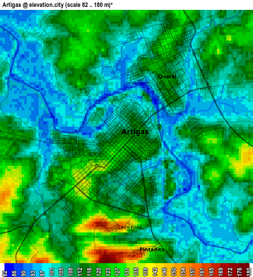
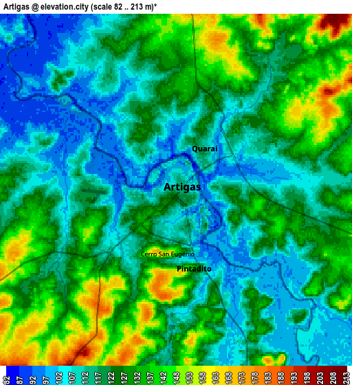
Below is the Elevation map of Artigas, which displays elevation range with different colors. Scale of the first map is from 82 to 180 m (269 to 591 ft) with average elevation of 110.7 meters (=363 ft) [note 1]
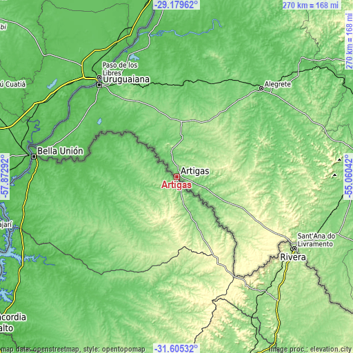
These maps also provides idea of topography and contour of this city, they are displayed at different zoom levels. More info about maps, scale and edge coordinates you can find below images.
| \ | Map #1 | Map #2 | Topo.Map |
| Scale [m] | 82..180 m | 82..213 m | × |
| Scale [ft] | 269..591 ft | 269..699 ft | × |
| Average | 110.7 m = 363 ft | 122.4 m = 402 ft | × |
| Width | 8.43 km = 5.2 mi | 16.86 km = 10.5 mi | 269.7 km = 167.6 mi |
| Height | 8.43 km = 5.2 mi | 16.86 km = 10.5 mi | 269.7 km = 167.6 mi |
| ↑Max Latitude | -30.362089° | -30.324164° | -29.17962° |
| Latitude at center | -30.4° | -30.4° | -30.4° |
| ↓Min Latitude | -30.437896° | -30.475777° | -31.60532° |
| ← Min Longitude | -56.510615° | -56.554561° | -57.87292° |
| Longitude center | -56.46667° | -56.46667° | -56.46667° |
| →Max Longitude | -56.422725° | -56.378779° | -55.06042° |
Nearby cities:
Cities around Artigas sort by population:
• Salto elevation 18 m
180.1 km,  232°
232°
• Rivera 194 m
104.1 km,  122°
122°
• Tacuarembó 135 m
153.6 km,  162°
162°
• Bella Unión 53 m
109.8 km,  278°
278°
• Tranqueras 187 m
112.2 km,  142°
142°
• Minas de Corrales 153 m
161.4 km, 143°
• Tomás Gomensoro 94 m
93 km,  268°
268°
• Villa Constitución 47 m
151.7 km,  240°
240°
• Baltasar Brum 144 m
89.6 km,  246°
246°
• Las Piedras 68 m
108.1 km, 278°
• Belén 44 m
132.5 km, 251°
• Curtina 122 m
197.4 km,  170°
170°
Multilingual:
 En español:
Artigas elevación 113 m.
 En France:
Artigas élévation 113 m.


Sources and notes:
- [note 1] Map square and city borders are not equal. Map elevation data is calculated only from area inside that square.
- [src 1] Elevation data from geonames database provided with same terms of usage.
- [src 2] The elevation map of Artigas is generated using elevation data from NASA's 3 arcsec (90m) resolution SRTM data.
- [src 3] Base (background) map © OpenStreetMap contributors tiles are generated by Geofabrik and OpenTopoMap.
Copyright & License:
This Artigas Elevation Map is licensed under CC BY-SA. You may reuse any part from this page, if you give a proper credit by linking to this URL:
 More info on terms of use page.