Guichón elevation
Guichón (Paysandú, Guichon), Uruguay elevation is 94 meters and Guichón elevation in feet is 308 ft above sea level [src 1]. Guichón is a populated place (feature code) with elevation that is 23 meters (75 ft) bigger than average city elevation in Uruguay.
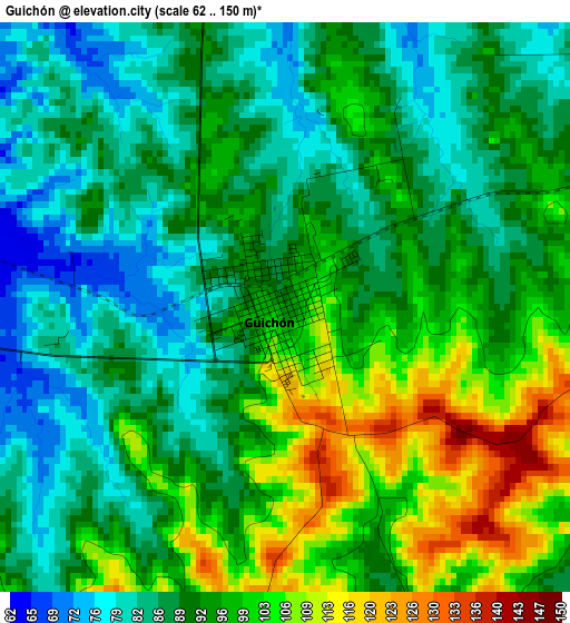
Below is the Elevation map of Guichón, which displays elevation range with different colors. Scale of the first map is from 62 to 150 m (203 to 492 ft) with average elevation of 93.1 meters (=305 ft) [note 1]
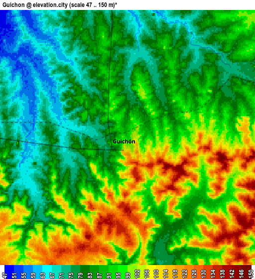
These maps also provides idea of topography and contour of this city, they are displayed at different zoom levels. More info about maps, scale and edge coordinates you can find below images.
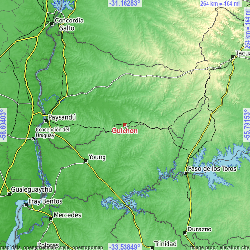
| \ | Map #1 | Map #2 | Topo.Map |
| Scale [m] | 62..150 m | 47..150 m | × |
| Scale [ft] | 203..492 ft | 154..492 ft | × |
| Average | 93.1 m = 305 ft | 90.7 m = 298 ft | × |
| Width | 8.25 km = 5.1 mi | 16.51 km = 10.3 mi | 264.1 km = 164.1 mi |
| Height | 8.26 km = 5.1 mi | 16.51 km = 10.3 mi | 264.2 km = 164.2 mi |
| ↑Max Latitude | -32.321331° | -32.284187° | -31.16283° |
| Latitude at center | -32.35846° | -32.35846° | -32.35846° |
| ↓Min Latitude | -32.395574° | -32.432672° | -33.53849° |
| ← Min Longitude | -57.241725° | -57.285671° | -58.60403° |
| Longitude center | -57.19778° | -57.19778° | -57.19778° |
| →Max Longitude | -57.153835° | -57.109889° | -55.79153° |
Nearby cities:
Cities around Guichón sort by population:
• Paysandú elevation 50 m
83.1 km,  273°
273°
• Mercedes 29 m
126.2 km,  218°
218°
• Young 86 m
55.2 km,  226°
226°
• Paso de los Toros 57 m
81.7 km,  128°
128°
• Quebracho 66 m
81.3 km,  305°
305°
• Nuevo Berlín 11 m
106.1 km, 229°
• San Javier 13 m
94.1 km,  248°
248°
• San Félix 7 m
84.8 km, 270°
• Piedras Coloradas 91 m
38.6 km, 267°
• Estación Porvenir 63 m
61.6 km, 268°
• Curtina 122 m
104.3 km,  77°
77°
• Carlos Reyles 108 m
102.9 km,  138°
138°
Multilingual:
 En español:
Guichón elevación 94 m.
 En France:
Guichón élévation 94 m.


Sources and notes:
- [note 1] Map square and city borders are not equal. Map elevation data is calculated only from area inside that square.
- [src 1] Elevation data from geonames database provided with same terms of usage.
- [src 2] The elevation map of Guichón is generated using elevation data from NASA's 3 arcsec (90m) resolution SRTM data.
- [src 3] Base (background) map © OpenStreetMap contributors tiles are generated by Geofabrik and OpenTopoMap.
Copyright & License:
This Guichón Elevation Map is licensed under CC BY-SA. You may reuse any part from this page, if you give a proper credit by linking to this URL:
 More info on terms of use page.