Paso de los Toros elevation
Paso de los Toros (Tacuarembó, Paso De Los Toros), Uruguay elevation is 57 meters and Paso de los Toros elevation in feet is 187 ft above sea level [src 1]. Paso de los Toros is a populated place (feature code) with elevation that is 14 meters (46 ft) smaller than average city elevation in Uruguay.
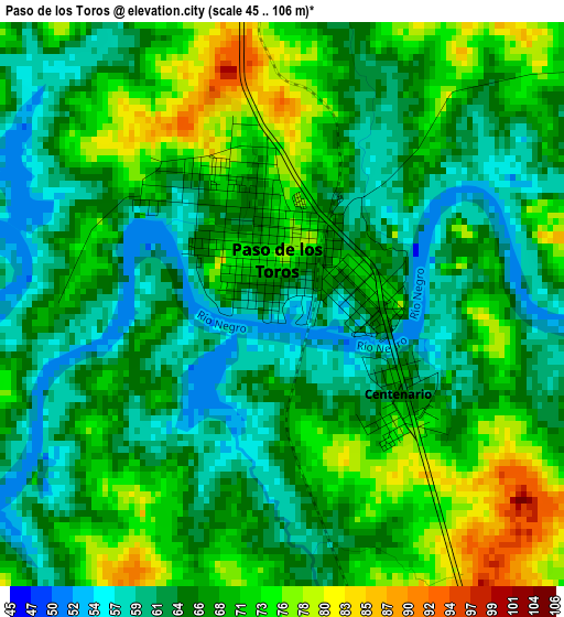
Below is the Elevation map of Paso de los Toros, which displays elevation range with different colors. Scale of the first map is from 45 to 106 m (148 to 348 ft) with average elevation of 67.3 meters (=221 ft) [note 1]
These maps also provides idea of topography and contour of this city, they are displayed at different zoom levels. More info about maps, scale and edge coordinates you can find below images.
| \ | Map #1 | Map #2 | Topo.Map |
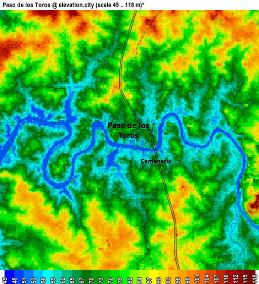
| Scale [m] | 45..106 m | 45..118 m | × |
| Scale [ft] | 148..348 ft | 148..387 ft | × |
| Average | 67.3 m = 221 ft | 75.3 m = 247 ft | × |
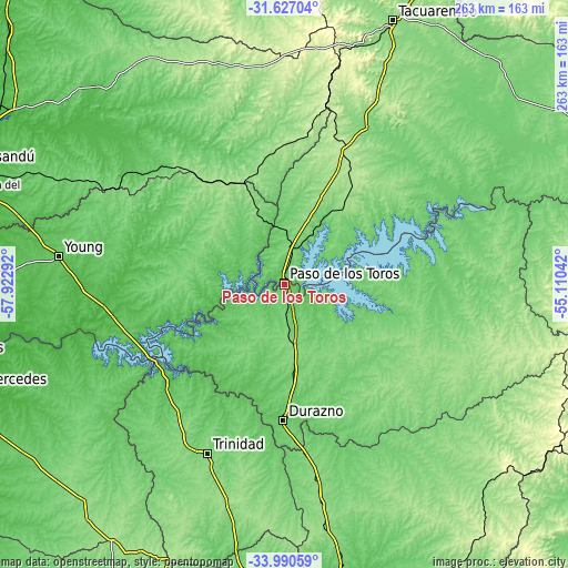
| Width | 8.21 km = 5.1 mi | 16.43 km = 10.2 mi | 262.8 km = 163.3 mi |
| Height | 8.21 km = 5.1 mi | 16.43 km = 10.2 mi | 262.8 km = 163.3 mi |
| ↑Max Latitude | -32.77973° | -32.742775° | -31.62704° |
| Latitude at center | -32.81667° | -32.81667° | -32.81667° |
| ↓Min Latitude | -32.853594° | -32.890503° | -33.99059° |
| ← Min Longitude | -56.560615° | -56.604561° | -57.92292° |
| Longitude center | -56.51667° | -56.51667° | -56.51667° |
| →Max Longitude | -56.472725° | -56.428779° | -55.11042° |
Nearby cities:
Cities around Paso de los Toros sort by population:
• Durazno elevation 93 m
62.7 km,  180°
180°
• Trinidad 142 m
85.6 km,  204°
204°
• Young 86 m
104.6 km,  277°
277°
• Sarandí del Yi 126 m
101.4 km,  125°
125°
• Sarandí Grande 132 m
103.3 km,  170°
170°
• Guichón 94 m
81.7 km,  308°
308°
• Villa del Carmen 153 m
66.7 km, 134°
• La Paloma 146 m
87.9 km,  83°
83°
• Santa Bernardina 83 m
59.7 km, 180°
• Blanquillo 91 m
82.8 km,  86°
86°
• Curtina 122 m
83.1 km,  26°
26°
• Carlos Reyles 108 m
26.9 km, 172°
Multilingual:
 En español:
Paso de los Toros elevación 57 m.
 En France:
Paso de los Toros élévation 57 m.
 Auf Deutsch:
Paso de los Toros höhe über dem Meeresspiegel ist 57 m.

Sources and notes:
- [note 1] Map square and city borders are not equal. Map elevation data is calculated only from area inside that square.
- [src 1] Elevation data from geonames database provided with same terms of usage.
- [src 2] The elevation map of Paso de los Toros is generated using elevation data from NASA's 3 arcsec (90m) resolution SRTM data.
- [src 3] Base (background) map © OpenStreetMap contributors tiles are generated by Geofabrik and OpenTopoMap.
Copyright & License:
This Paso de los Toros Elevation Map is licensed under CC BY-SA. You may reuse any part from this page, if you give a proper credit by linking to this URL:
 More info on terms of use page.