Sarandí del Yi elevation
Sarandí del Yi (Durazno, Sarandí Del Yí), Uruguay elevation is 126 meters and Sarandí del Yi elevation in feet is 413 ft above sea level [src 1]. Sarandí del Yi is a populated place (feature code) with elevation that is 55 meters (180 ft) bigger than average city elevation in Uruguay.
Below is the Elevation map of Sarandí del Yi, which displays elevation range with different colors. Scale of the first map is from 112 to 162 m (367 to 531 ft) with average elevation of 125.8 meters (=413 ft) [note 1]
These maps also provides idea of topography and contour of this city, they are displayed at different zoom levels. More info about maps, scale and edge coordinates you can find below images.
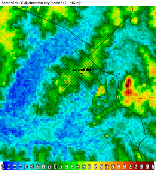
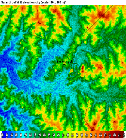
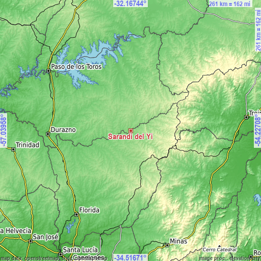
| \ | Map #1 | Map #2 | Topo.Map |
| Scale [m] | 112..162 m | 110..163 m | × |
| Scale [ft] | 367..531 ft | 361..535 ft | × |
| Average | 125.8 m = 413 ft | 130.4 m = 428 ft | × |
| Width | 8.16 km = 5.1 mi | 16.33 km = 10.1 mi | 261.2 km = 162.3 mi |
| Height | 8.16 km = 5.1 mi | 16.33 km = 10.1 mi | 261.2 km = 162.3 mi |
| ↑Max Latitude | -33.313284° | -33.276552° | -32.16744° |
| Latitude at center | -33.35° | -33.35° | -33.35° |
| ↓Min Latitude | -33.386701° | -33.423387° | -34.51671° |
| ← Min Longitude | -55.677275° | -55.721221° | -57.03958° |
| Longitude center | -55.63333° | -55.63333° | -55.63333° |
| →Max Longitude | -55.589385° | -55.545439° | -54.22708° |
Nearby cities:
Cities around Sarandí del Yi sort by population:
• Durazno elevation 93 m
82.7 km,  267°
267°
• Florida 74 m
98.8 km,  212°
212°
• Sarandí Grande 132 m
77.6 km,  236°
236°
• Villa del Carmen 153 m
37 km,  289°
289°
• Casupá 125 m
83.4 km,  180°
180°
• José Batlle y Ordóñez 293 m
49.7 km,  105°
105°
• Santa Clara de Olimar 294 m
79.8 km,  53°
53°
• La Paloma 146 m
69.4 km,  3°
3°
• Alejandro Gallinal 235 m
57.6 km,  171°
171°
• Santa Bernardina 83 m
82.8 km, 269°
• Blanquillo 91 m
64.9 km, 0°
• Carlos Reyles 108 m
85 km, 292°
Multilingual:
 En español:
Sarandí del Yi elevación 126 m.
 En France:
Sarandí del Yi élévation 126 m.
 Auf Deutsch:
Sarandí del Yi höhe über dem Meeresspiegel ist 126 m.

Sources and notes:
- [note 1] Map square and city borders are not equal. Map elevation data is calculated only from area inside that square.
- [src 1] Elevation data from geonames database provided with same terms of usage.
- [src 2] The elevation map of Sarandí del Yi is generated using elevation data from NASA's 3 arcsec (90m) resolution SRTM data.
- [src 3] Base (background) map © OpenStreetMap contributors tiles are generated by Geofabrik and OpenTopoMap.
Copyright & License:
This Sarandí del Yi Elevation Map is licensed under CC BY-SA. You may reuse any part from this page, if you give a proper credit by linking to this URL:
 More info on terms of use page.