Florida elevation
Florida, Uruguay elevation is 74 meters and Florida elevation in feet is 243 ft above sea level [src 1]. Florida is a seat of a first-order administrative division (feature code) with elevation that is 3 meters (10 ft) bigger than average city elevation in Uruguay.
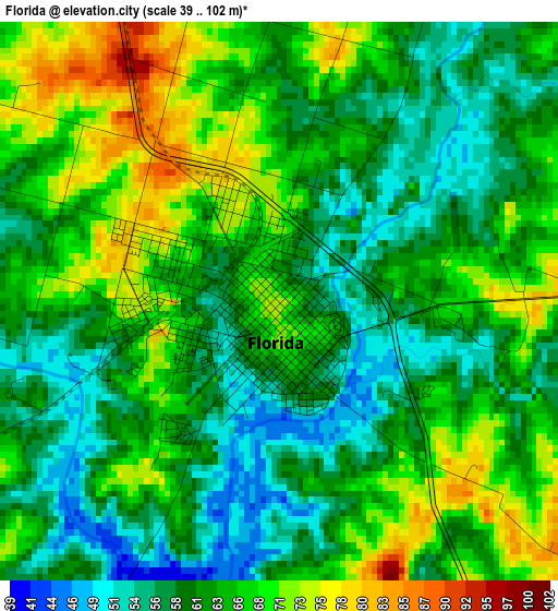
Below is the Elevation map of Florida, which displays elevation range with different colors. Scale of the first map is from 39 to 102 m (128 to 335 ft) with average elevation of 63.2 meters (=207 ft) [note 1]
These maps also provides idea of topography and contour of this city, they are displayed at different zoom levels. More info about maps, scale and edge coordinates you can find below images.
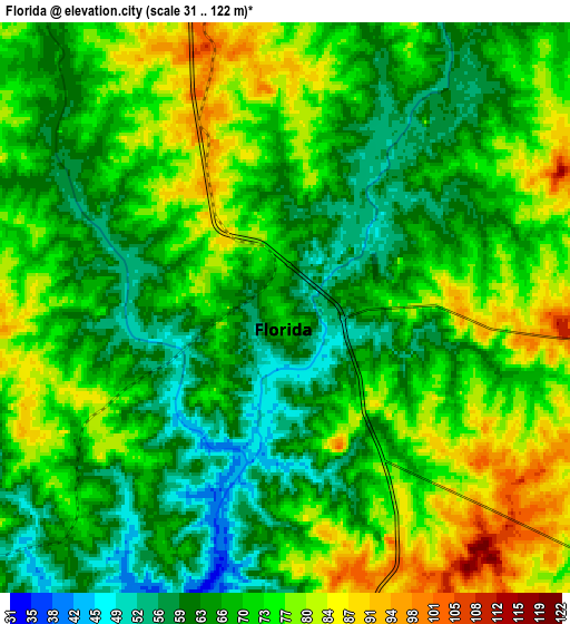
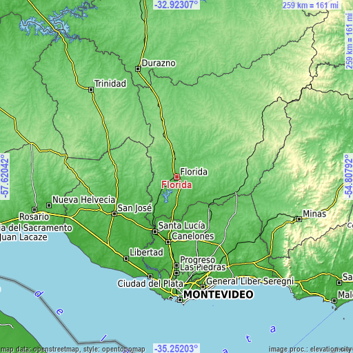
| \ | Map #1 | Map #2 | Topo.Map |
| Scale [m] | 39..102 m | 31..122 m | × |
| Scale [ft] | 128..335 ft | 102..400 ft | × |
| Average | 63.2 m = 207 ft | 69.9 m = 229 ft | × |
| Width | 8.09 km = 5 mi | 16.19 km = 10.1 mi | 259 km = 160.9 mi |
| Height | 8.09 km = 5 mi | 16.19 km = 10.1 mi | 259 km = 160.9 mi |
| ↑Max Latitude | -34.059161° | -34.022746° | -32.92307° |
| Latitude at center | -34.09556° | -34.09556° | -34.09556° |
| ↓Min Latitude | -34.131943° | -34.168311° | -35.25203° |
| ← Min Longitude | -56.258115° | -56.302061° | -57.62042° |
| Longitude center | -56.21417° | -56.21417° | -56.21417° |
| →Max Longitude | -56.170225° | -56.126279° | -54.80792° |
Nearby cities:
Cities around Florida sort by population:
• Canelones elevation 18 m
47.9 km,  187°
187°
• Santa Lucía 24 m
43 km,  202°
202°
• San Ramón 44 m
32.2 km,  132°
132°
• Sarandí Grande 132 m
41.8 km,  344°
344°
• Tala 84 m
49.7 km,  123°
123°
• Santa Rosa 58 m
47.6 km,  160°
160°
• Rodríguez 48 m
43.5 km,  223°
223°
• San Bautista 74 m
44.9 km,  148°
148°
• 25 de Mayo 58 m
15.5 km,  227°
227°
• 25 de Agosto 25 m
39.2 km,  206°
206°
• San Antonio 52 m
41.4 km, 162°
• Cardal 53 m
27 km, 216°
Multilingual:
 En español:
Florida elevación 74 m.
 En France:
Florida élévation 74 m.


Sources and notes:
- [note 1] Map square and city borders are not equal. Map elevation data is calculated only from area inside that square.
- [src 1] Elevation data from geonames database provided with same terms of usage.
- [src 2] The elevation map of Florida is generated using elevation data from NASA's 3 arcsec (90m) resolution SRTM data.
- [src 3] Base (background) map © OpenStreetMap contributors tiles are generated by Geofabrik and OpenTopoMap.
Copyright & License:
This Florida Elevation Map is licensed under CC BY-SA. You may reuse any part from this page, if you give a proper credit by linking to this URL:
 More info on terms of use page.