Melo elevation
Melo (Cerro Largo), Uruguay elevation is 115 meters and Melo elevation in feet is 377 ft above sea level [src 1]. Melo is a seat of a first-order administrative division (feature code) with elevation that is 44 meters (144 ft) bigger than average city elevation in Uruguay.
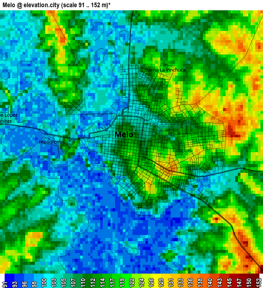
Below is the Elevation map of Melo, which displays elevation range with different colors. Scale of the first map is from 91 to 152 m (299 to 499 ft) with average elevation of 109.9 meters (=361 ft) [note 1]
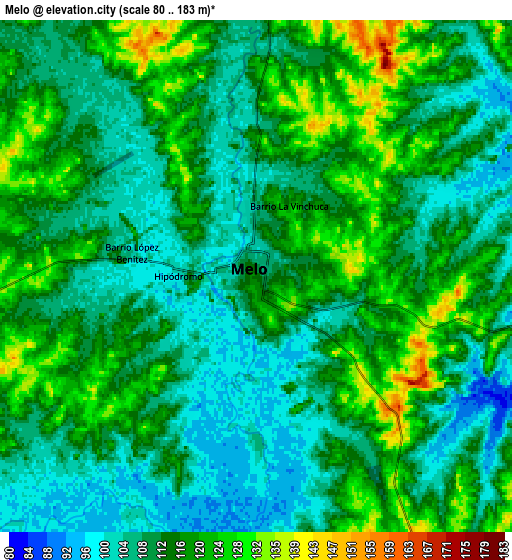
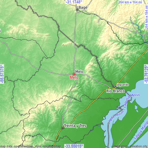
These maps also provides idea of topography and contour of this city, they are displayed at different zoom levels. More info about maps, scale and edge coordinates you can find below images.
| \ | Map #1 | Map #2 | Topo.Map |
| Scale [m] | 91..152 m | 80..183 m | × |
| Scale [ft] | 299..499 ft | 262..600 ft | × |
| Average | 109.9 m = 361 ft | 112.5 m = 369 ft | × |
| Width | 8.25 km = 5.1 mi | 16.51 km = 10.3 mi | 264.1 km = 164.1 mi |
| Height | 8.25 km = 5.1 mi | 16.51 km = 10.3 mi | 264.1 km = 164.1 mi |
| ↑Max Latitude | -32.333156° | -32.296017° | -31.1748° |
| Latitude at center | -32.37028° | -32.37028° | -32.37028° |
| ↓Min Latitude | -32.407389° | -32.444482° | -33.55015° |
| ← Min Longitude | -54.211445° | -54.255391° | -55.57375° |
| Longitude center | -54.1675° | -54.1675° | -54.1675° |
| →Max Longitude | -54.123555° | -54.079609° | -52.76125° |
Nearby cities:
Cities around Melo sort by population:
• Treinta y Tres elevation 52 m
98.1 km,  191°
191°
• Río Branco 9 m
77.6 km,  109°
109°
• José Pedro Varela 72 m
125.4 km,  195°
195°
• Vichadero 241 m
82.3 km,  323°
323°
• Vergara 31 m
67.3 km,  161°
161°
• Isidoro Noblía 134 m
45.6 km,  5°
5°
• Santa Clara de Olimar 294 m
95.2 km,  229°
229°
• Cebollatí 12 m
105.6 km, 160°
• La Paloma 146 m
138.4 km,  253°
253°
• Aceguá 177 m
55.4 km,  0°
0°
• Tupambaé 289 m
76.2 km, 227°
• Villa Sara 37 m
101 km, 193°
Multilingual:
 En español:
Melo elevación 115 m.
 En France:
Melo élévation 115 m.


Sources and notes:
- [note 1] Map square and city borders are not equal. Map elevation data is calculated only from area inside that square.
- [src 1] Elevation data from geonames database provided with same terms of usage.
- [src 2] The elevation map of Melo is generated using elevation data from NASA's 3 arcsec (90m) resolution SRTM data.
- [src 3] Base (background) map © OpenStreetMap contributors tiles are generated by Geofabrik and OpenTopoMap.
Copyright & License:
This Melo Elevation Map is licensed under CC BY-SA. You may reuse any part from this page, if you give a proper credit by linking to this URL:
 More info on terms of use page.