José Pedro Varela elevation
José Pedro Varela (Lavalleja, Jose Pedro Varela), Uruguay elevation is 72 meters and José Pedro Varela elevation in feet is 236 ft above sea level [src 1]. José Pedro Varela is a populated place (feature code) with elevation that is 1 meters (3 ft) bigger than average city elevation in Uruguay.
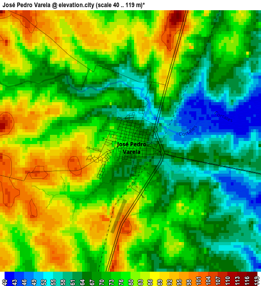
Below is the Elevation map of José Pedro Varela, which displays elevation range with different colors. Scale of the first map is from 40 to 119 m (131 to 390 ft) with average elevation of 75.1 meters (=246 ft) [note 1]
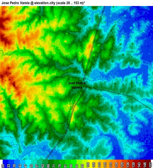
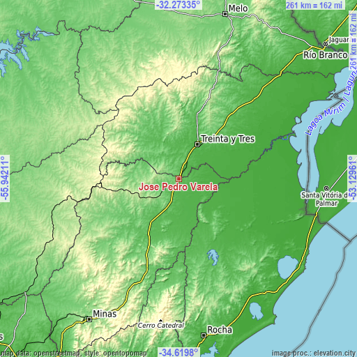
These maps also provides idea of topography and contour of this city, they are displayed at different zoom levels. More info about maps, scale and edge coordinates you can find below images.
| \ | Map #1 | Map #2 | Topo.Map |
| Scale [m] | 40..119 m | 28..153 m | × |
| Scale [ft] | 131..390 ft | 92..502 ft | × |
| Average | 75.1 m = 246 ft | 69.2 m = 227 ft | × |
| Width | 8.15 km = 5.1 mi | 16.31 km = 10.1 mi | 260.9 km = 162.1 mi |
| Height | 8.15 km = 5.1 mi | 16.31 km = 10.1 mi | 260.9 km = 162.1 mi |
| ↑Max Latitude | -33.417838° | -33.38115° | -32.27335° |
| Latitude at center | -33.45451° | -33.45451° | -33.45451° |
| ↓Min Latitude | -33.491167° | -33.527808° | -34.6198° |
| ← Min Longitude | -54.579805° | -54.623751° | -55.94211° |
| Longitude center | -54.53586° | -54.53586° | -54.53586° |
| →Max Longitude | -54.491915° | -54.447969° | -53.12961° |
Nearby cities:
Cities around José Pedro Varela sort by population:
• Treinta y Tres elevation 52 m
28.4 km,  29°
29°
• Lascano 45 m
39 km,  128°
128°
• Vergara 31 m
79.5 km,  44°
44°
• Aiguá 94 m
85.9 km,  193°
193°
• José Batlle y Ordóñez 293 m
53.9 km,  268°
268°
• Santa Clara de Olimar 294 m
70.3 km,  327°
327°
• Mariscala 92 m
68.9 km,  198°
198°
• Cebollatí 12 m
72 km,  73°
73°
• Dieciocho de Julio 13 m
94.5 km,  105°
105°
• Tupambaé 289 m
72.3 km,  342°
342°
• Velázquez 66 m
68.9 km,  159°
159°
• Villa Sara 37 m
24.8 km, 25°
Multilingual:
 En español:
José Pedro Varela elevación 72 m.
 En France:
José Pedro Varela élévation 72 m.
 Auf Deutsch:
José Pedro Varela höhe über dem Meeresspiegel ist 72 m.

Sources and notes:
- [note 1] Map square and city borders are not equal. Map elevation data is calculated only from area inside that square.
- [src 1] Elevation data from geonames database provided with same terms of usage.
- [src 2] The elevation map of José Pedro Varela is generated using elevation data from NASA's 3 arcsec (90m) resolution SRTM data.
- [src 3] Base (background) map © OpenStreetMap contributors tiles are generated by Geofabrik and OpenTopoMap.
Copyright & License:
This José Pedro Varela Elevation Map is licensed under CC BY-SA. You may reuse any part from this page, if you give a proper credit by linking to this URL:
 More info on terms of use page.