Vichadero elevation
Vichadero (Rivera), Uruguay elevation is 241 meters and Vichadero elevation in feet is 791 ft above sea level [src 1]. Vichadero is a populated place (feature code) with elevation that is 170 meters (558 ft) bigger than average city elevation in Uruguay.
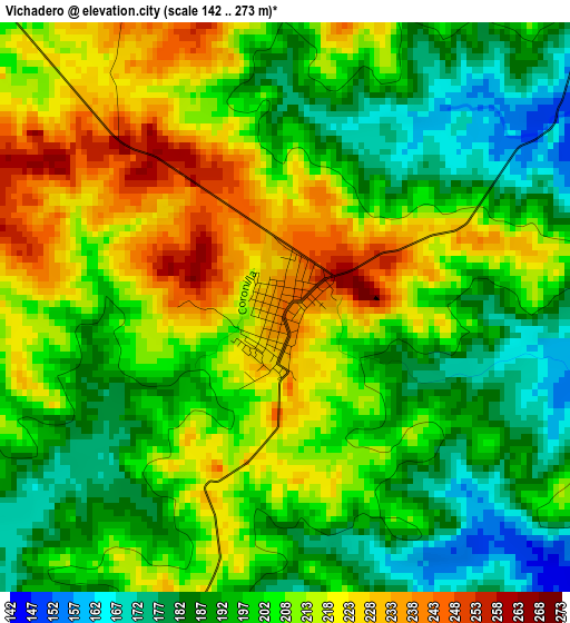
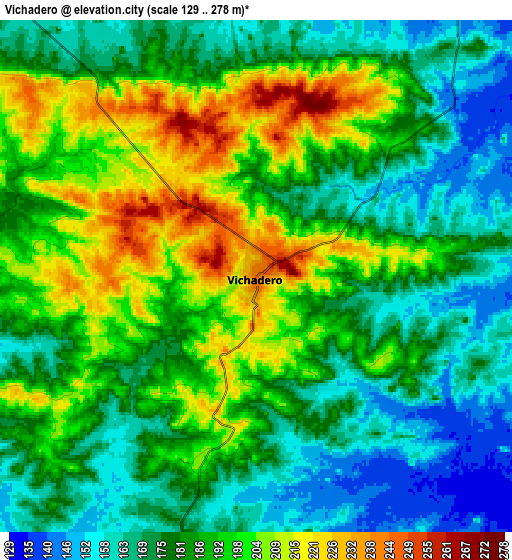
Below is the Elevation map of Vichadero, which displays elevation range with different colors. Scale of the first map is from 142 to 273 m (466 to 896 ft) with average elevation of 203.8 meters (=669 ft) [note 1]
These maps also provides idea of topography and contour of this city, they are displayed at different zoom levels. More info about maps, scale and edge coordinates you can find below images.
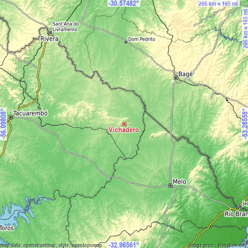
| \ | Map #1 | Map #2 | Topo.Map |
| Scale [m] | 142..273 m | 129..278 m | × |
| Scale [ft] | 466..896 ft | 423..912 ft | × |
| Average | 203.8 m = 669 ft | 184.8 m = 606 ft | × |
| Width | 8.31 km = 5.2 mi | 16.62 km = 10.3 mi | 265.8 km = 165.2 mi |
| Height | 8.31 km = 5.2 mi | 16.62 km = 10.3 mi | 265.8 km = 165.2 mi |
| ↑Max Latitude | -31.740575° | -31.703194° | -30.57482° |
| Latitude at center | -31.77794° | -31.77794° | -31.77794° |
| ↓Min Latitude | -31.81529° | -31.852625° | -32.96561° |
| ← Min Longitude | -54.735775° | -54.779721° | -56.09808° |
| Longitude center | -54.69183° | -54.69183° | -54.69183° |
| →Max Longitude | -54.647885° | -54.603939° | -53.28558° |
Nearby cities:
Cities around Vichadero sort by population:
• Rivera elevation 194 m
126.8 km,  319°
319°
• Tacuarembó 135 m
122.1 km,  273°
273°
• Melo 115 m
82.3 km,  143°
143°
• Tranqueras 187 m
119.1 km,  302°
302°
• Minas de Corrales 153 m
77.1 km,  287°
287°
• Isidoro Noblía 134 m
57.5 km,  110°
110°
• Santa Clara de Olimar 294 m
129.5 km,  190°
190°
• La Paloma 146 m
134.7 km,  218°
218°
• Aceguá 177 m
51 km,  101°
101°
• Tupambaé 289 m
117.6 km,  183°
183°
• Blanquillo 91 m
141.1 km, 218°
• Curtina 122 m
140.6 km,  252°
252°
Multilingual:
 En español:
Vichadero elevación 241 m.
 En France:
Vichadero élévation 241 m.
 Auf Deutsch:
Vichadero höhe über dem Meeresspiegel ist 241 m.

Sources and notes:
- [note 1] Map square and city borders are not equal. Map elevation data is calculated only from area inside that square.
- [src 1] Elevation data from geonames database provided with same terms of usage.
- [src 2] The elevation map of Vichadero is generated using elevation data from NASA's 3 arcsec (90m) resolution SRTM data.
- [src 3] Base (background) map © OpenStreetMap contributors tiles are generated by Geofabrik and OpenTopoMap.
Copyright & License:
This Vichadero Elevation Map is licensed under CC BY-SA. You may reuse any part from this page, if you give a proper credit by linking to this URL:
 More info on terms of use page.