Minas elevation
Minas (Lavalleja), Uruguay elevation is 134 meters and Minas elevation in feet is 440 ft above sea level [src 1]. Minas is a seat of a first-order administrative division (feature code) with elevation that is 63 meters (207 ft) bigger than average city elevation in Uruguay.
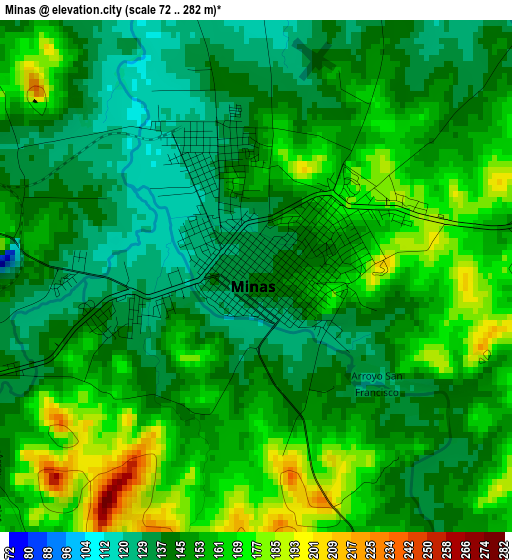
Below is the Elevation map of Minas, which displays elevation range with different colors. Scale of the first map is from 72 to 282 m (236 to 925 ft) with average elevation of 150.8 meters (=495 ft) [note 1]
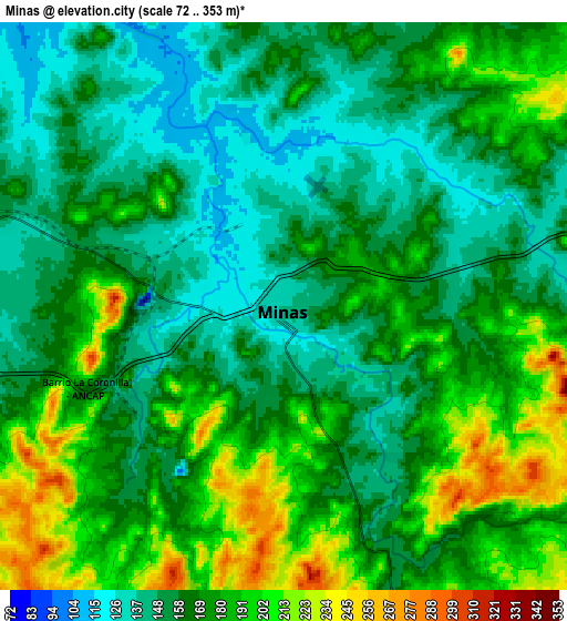
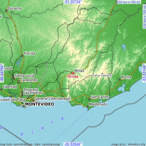
These maps also provides idea of topography and contour of this city, they are displayed at different zoom levels. More info about maps, scale and edge coordinates you can find below images.
| \ | Map #1 | Map #2 | Topo.Map |
| Scale [m] | 72..282 m | 72..353 m | × |
| Scale [ft] | 236..925 ft | 236..1158 ft | × |
| Average | 150.8 m = 495 ft | 169.7 m = 557 ft | × |
| Width | 8.07 km = 5 mi | 16.13 km = 10 mi | 258.1 km = 160.4 mi |
| Height | 8.07 km = 5 mi | 16.13 km = 10 mi | 258.1 km = 160.4 mi |
| ↑Max Latitude | -34.339612° | -34.303318° | -33.20724° |
| Latitude at center | -34.37589° | -34.37589° | -34.37589° |
| ↓Min Latitude | -34.412152° | -34.448399° | -35.52846° |
| ← Min Longitude | -55.281655° | -55.325601° | -56.64396° |
| Longitude center | -55.23771° | -55.23771° | -55.23771° |
| →Max Longitude | -55.193765° | -55.149819° | -53.83146° |
Nearby cities:
Cities around Minas sort by population:
• San Carlos elevation 28 m
54.7 km,  147°
147°
• Piriápolis 17 m
54.3 km,  183°
183°
• Pan de Azúcar 22 m
44.8 km, 179°
• Tala 84 m
48.4 km,  274°
274°
• Solís de Mataojo 40 m
32.6 km,  220°
220°
• Aiguá 94 m
48.1 km,  66°
66°
• Casupá 125 m
48.6 km,  309°
309°
• Migues 79 m
37.9 km,  250°
250°
• Soca 11 m
54.6 km,  231°
231°
• Mariscala 92 m
56.4 km,  48°
48°
• Montes 39 m
32.5 km, 246°
• La Floresta 18 m
58.6 km, 223°
Multilingual:
 En español:
Minas elevación 134 m.
 En France:
Minas élévation 134 m.


Sources and notes:
- [note 1] Map square and city borders are not equal. Map elevation data is calculated only from area inside that square.
- [src 1] Elevation data from geonames database provided with same terms of usage.
- [src 2] The elevation map of Minas is generated using elevation data from NASA's 3 arcsec (90m) resolution SRTM data.
- [src 3] Base (background) map © OpenStreetMap contributors tiles are generated by Geofabrik and OpenTopoMap.
Copyright & License:
This Minas Elevation Map is licensed under CC BY-SA. You may reuse any part from this page, if you give a proper credit by linking to this URL:
 More info on terms of use page.