Piriápolis elevation
Piriápolis (Maldonado, Piriapolis), Uruguay elevation is 17 meters and Piriápolis elevation in feet is 56 ft above sea level [src 1]. Piriápolis is a populated place (feature code) with elevation that is 54 meters (177 ft) smaller than average city elevation in Uruguay.
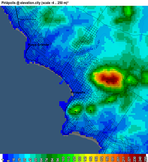
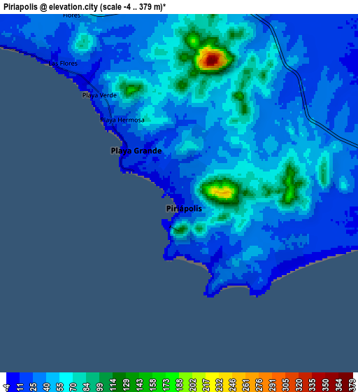
Below is the Elevation map of Piriápolis, which displays elevation range with different colors. Scale of the first map is from -4 to 250 m (-13 to 820 ft) with average elevation of 42.7 meters (=140 ft) [note 1]
These maps also provides idea of topography and contour of this city, they are displayed at different zoom levels. More info about maps, scale and edge coordinates you can find below images.
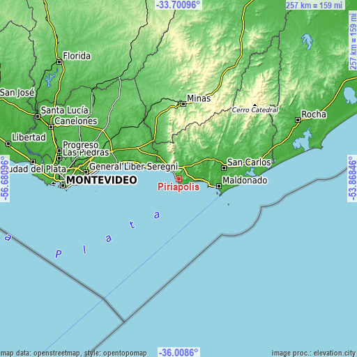
| \ | Map #1 | Map #2 | Topo.Map |
| Scale [m] | -4..250 m | -4..379 m | × |
| Scale [ft] | -13..820 ft | -13..1243 ft | × |
| Average | 42.7 m = 140 ft | 43.7 m = 143 ft | × |
| Width | 8.02 km = 5 mi | 16.04 km = 10 mi | 256.6 km = 159.4 mi |
| Height | 8.02 km = 5 mi | 16.04 km = 10 mi | 256.6 km = 159.4 mi |
| ↑Max Latitude | -34.826804° | -34.790722° | -33.70096° |
| Latitude at center | -34.86287° | -34.86287° | -34.86287° |
| ↓Min Latitude | -34.89892° | -34.934955° | -36.0086° |
| ← Min Longitude | -55.318655° | -55.362601° | -56.68096° |
| Longitude center | -55.27471° | -55.27471° | -55.27471° |
| →Max Longitude | -55.230765° | -55.186819° | -53.86846° |
Nearby cities:
Cities around Piriápolis sort by population:
• Maldonado elevation 30 m
29.9 km,  97°
97°
• Minas 134 m
54.3 km,  3°
3°
• San Carlos 28 m
33.5 km,  76°
76°
• Punta del Este 15 m
32.5 km,  106°
106°
• Pan de Azúcar 22 m
10 km,  20°
20°
• Atlántida 22 m
45.3 km,  282°
282°
• Solís de Mataojo 40 m
34.2 km,  328°
328°
• Las Toscas 2 m
42.8 km,  289°
289°
• Migues 79 m
52.8 km,  322°
322°
• Soca 11 m
43.8 km,  296°
296°
• Montes 39 m
48.8 km, 327°
• La Floresta 18 m
39 km, 287°
Multilingual:
 En español:
Piriápolis elevación 17 m.
 En France:
Piriápolis élévation 17 m.
 Auf Deutsch:
Piriápolis höhe über dem Meeresspiegel ist 17 m.

Sources and notes:
- [note 1] Map square and city borders are not equal. Map elevation data is calculated only from area inside that square.
- [src 1] Elevation data from geonames database provided with same terms of usage.
- [src 2] The elevation map of Piriápolis is generated using elevation data from NASA's 3 arcsec (90m) resolution SRTM data.
- [src 3] Base (background) map © OpenStreetMap contributors tiles are generated by Geofabrik and OpenTopoMap.
Copyright & License:
This Piriápolis Elevation Map is licensed under CC BY-SA. You may reuse any part from this page, if you give a proper credit by linking to this URL:
 More info on terms of use page.