Acalanes Ridge elevation
Acalanes Ridge (California, Contra Costa County), United States elevation is 142 meters and Acalanes Ridge elevation in feet is 466 ft above sea level [src 1]. Acalanes Ridge is a populated place (feature code) with elevation that is 137 meters (449 ft) smaller than average city elevation in United States.
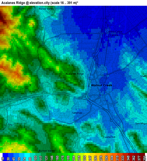
Below is the Elevation map of Acalanes Ridge, which displays elevation range with different colors. Scale of the first map is from 16 to 391 m (52 to 1283 ft) with average elevation of 98.1 meters (=322 ft) [note 1]
These maps also provides idea of topography and contour of this city, they are displayed at different zoom levels. More info about maps, scale and edge coordinates you can find below images.
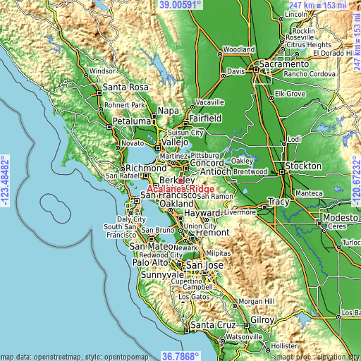
| \ | Map #1 | Topo.Map |
| Scale [m] | 16..391 m | × |
| Scale [ft] | 52..1283 ft | × |
| Average | 98.1 m = 322 ft | × |
| Width | 7.71 km = 4.8 mi | 246.7 km = 153.3 mi |
| Height | 7.71 km = 4.8 mi | 246.7 km = 153.3 mi |
| ↑Max Latitude | 37.939386° | 39.00591° |
| Latitude at center | 37.90472° | 37.90472° |
| ↓Min Latitude | 37.870038° | 36.7868° |
| ← Min Longitude | -122.122515° | -123.48482° |
| Longitude center | -122.07857° | -122.07857° |
| →Max Longitude | -122.034625° | -120.67232° |
Nearby cities:
Cities around Acalanes Ridge sort by population:
• Concord elevation 25 m
9.1 km,  27°
27°
• Walnut Creek 54 m
1.2 km,  81°
81°
• Danville 111 m
11.5 km,  143°
143°
• Pleasant Hill 16 m
5.1 km,  17°
17°
• Lafayette 94 m
4.1 km,  238°
238°
• Orinda 150 m
9.4 km,  250°
250°
• Moraga 149 m
9 km,  210°
210°
• Alamo 83 m
7.3 km,  146°
146°
• Waldon 24 m
3.1 km,  40°
40°
• Contra Costa Centre 33 m
3.1 km, 35°
• Saranap 58 m
2.2 km,  174°
174°
• Pacheco 21 m
8.8 km,  1°
1°
Multilingual:
 En español:
Acalanes Ridge elevación 142 m.
 En France:
Acalanes Ridge élévation 142 m.
 Auf Deutsch:
Acalanes Ridge höhe über dem Meeresspiegel ist 142 m.

Sources and notes:
- [note 1] Map square and city borders are not equal. Map elevation data is calculated only from area inside that square.
- [src 1] Elevation data from geonames database provided with same terms of usage.
- [src 2] The elevation map of Acalanes Ridge is generated using elevation data from NASA's 3 arcsec (90m) resolution SRTM data.
- [src 3] Base (background) map © OpenStreetMap contributors tiles are generated by Geofabrik and OpenTopoMap.
Copyright & License:
This Acalanes Ridge Elevation Map is licensed under CC BY-SA. You may reuse any part from this page, if you give a proper credit by linking to this URL:
 More info on terms of use page.