Lutherville-Timonium elevation
Lutherville-Timonium (Maryland, Baltimore County), United States elevation is 101 meters and Lutherville-Timonium elevation in feet is 331 ft above sea level [src 1]. Lutherville-Timonium is a populated place (feature code) with elevation that is 178 meters (584 ft) smaller than average city elevation in United States.
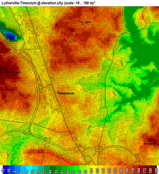
Below is the Elevation map of Lutherville-Timonium, which displays elevation range with different colors. Scale of the first map is from -18 to 188 m (-59 to 617 ft) with average elevation of 115.1 meters (=378 ft) [note 1]
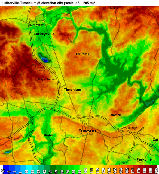
These maps also provides idea of topography and contour of this city, they are displayed at different zoom levels. More info about maps, scale and edge coordinates you can find below images.
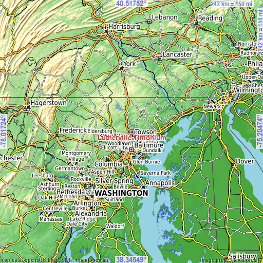
| \ | Map #1 | Map #2 | Topo.Map |
| Scale [m] | -18..188 m | -18..205 m | × |
| Scale [ft] | -59..617 ft | -59..673 ft | × |
| Average | 115.1 m = 378 ft | 124 m = 407 ft | × |
| Width | 7.55 km = 4.7 mi | 15.09 km = 9.4 mi | 241.5 km = 150.1 mi |
| Height | 7.55 km = 4.7 mi | 15.09 km = 9.4 mi | 241.5 km = 150.1 mi |
| ↑Max Latitude | 39.4739° | 39.507814° | 40.51752° |
| Latitude at center | 39.43997° | 39.43997° | 39.43997° |
| ↓Min Latitude | 39.406023° | 39.37206° | 38.34549° |
| ← Min Longitude | -76.654935° | -76.698881° | -78.01724° |
| Longitude center | -76.61099° | -76.61099° | -76.61099° |
| →Max Longitude | -76.567045° | -76.523099° | -75.20474° |
Nearby cities:
Cities around Lutherville-Timonium sort by population:
• Towson elevation 148 m
4.3 km,  169°
169°
• Pikesville 153 m
12 km,  232°
232°
• Parkville 104 m
9.3 km,  138°
138°
• Carney 109 m
9.1 km,  124°
124°
• Hunt Valley 89 m
7.1 km,  338°
338°
• Cockeysville 91 m
5.4 km,  328°
328°
• Overlea 70 m
11.5 km, 137°
• Mays Chapel 154 m
3.4 km,  257°
257°
• Timonium 127 m
0.8 km,  246°
246°
• Lutherville 128 m
2.5 km,  211°
211°
• Hampton 104 m
3 km,  130°
130°
• Arlington 135 m
11.9 km, 211°
Multilingual:
 En español:
Lutherville-Timonium elevación 101 m.
 En France:
Lutherville-Timonium élévation 101 m.
 Auf Deutsch:
Lutherville-Timonium höhe über dem Meeresspiegel ist 101 m.
 На русском:
Lutherville-Timonium высота над уровнем моря 101 м
Sources and notes:
- [note 1] Map square and city borders are not equal. Map elevation data is calculated only from area inside that square.
- [src 1] Elevation data from geonames database provided with same terms of usage.
- [src 2] The elevation map of Lutherville-Timonium is generated using elevation data from NASA's 3 arcsec (90m) resolution SRTM data.
- [src 3] Base (background) map © OpenStreetMap contributors tiles are generated by Geofabrik and OpenTopoMap.
Copyright & License:
This Lutherville-Timonium Elevation Map is licensed under CC BY-SA. You may reuse any part from this page, if you give a proper credit by linking to this URL:
 More info on terms of use page.