Fort Belvoir elevation
Fort Belvoir (Virginia, Fairfax County), United States elevation is 43 meters and Fort Belvoir elevation in feet is 141 ft above sea level [src 1]. Fort Belvoir is a populated place (feature code) with elevation that is 236 meters (774 ft) smaller than average city elevation in United States.
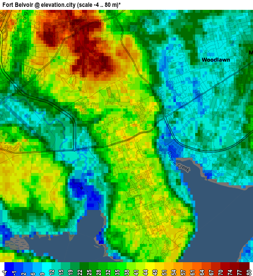
Below is the Elevation map of Fort Belvoir, which displays elevation range with different colors. Scale of the first map is from -4 to 80 m (-13 to 262 ft) with average elevation of 30 meters (=98 ft) [note 1]
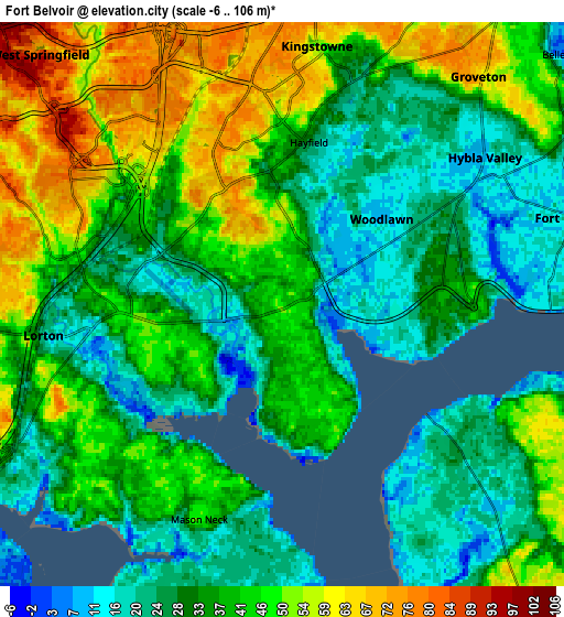
These maps also provides idea of topography and contour of this city, they are displayed at different zoom levels. More info about maps, scale and edge coordinates you can find below images.
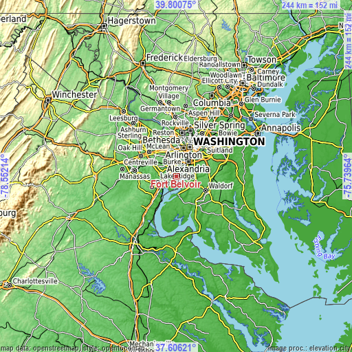
| \ | Map #1 | Map #2 | Topo.Map |
| Scale [m] | -4..80 m | -6..106 m | × |
| Scale [ft] | -13..262 ft | -20..348 ft | × |
| Average | 30 m = 98 ft | 37.9 m = 124 ft | × |
| Width | 7.63 km = 4.7 mi | 15.25 km = 9.5 mi | 244 km = 151.6 mi |
| Height | 7.63 km = 4.7 mi | 15.25 km = 9.5 mi | 244 km = 151.6 mi |
| ↑Max Latitude | 38.746182° | 38.780448° | 39.80075° |
| Latitude at center | 38.7119° | 38.7119° | 38.7119° |
| ↓Min Latitude | 38.677601° | 38.643286° | 37.60621° |
| ← Min Longitude | -77.189835° | -77.233781° | -78.55214° |
| Longitude center | -77.14589° | -77.14589° | -77.14589° |
| →Max Longitude | -77.101945° | -77.057999° | -75.73964° |
Nearby cities:
Cities around Fort Belvoir sort by population:
• Springfield elevation 77 m
9.3 km,  337°
337°
• Woodlawn 11 m
1.3 km,  64°
64°
• Rose Hill 70 m
9 km,  18°
18°
• Lorton 47 m
7.2 km,  263°
263°
• Franconia 79 m
7.8 km,  359°
359°
• Fort Hunt 16 m
8 km,  72°
72°
• Hybla Valley 10 m
6.7 km,  53°
53°
• Groveton 65 m
8.1 km,  40°
40°
• Newington 32 m
4.5 km,  311°
311°
• Mount Vernon 14 m
3.4 km,  76°
76°
• Laurel Hill 68 m
7.9 km,  273°
273°
• Hayfield 23 m
4.5 km,  11°
11°
Multilingual:
 En español:
Fort Belvoir elevación 43 m.
 En France:
Fort Belvoir élévation 43 m.
 Auf Deutsch:
Fort Belvoir höhe über dem Meeresspiegel ist 43 m.

Sources and notes:
- [note 1] Map square and city borders are not equal. Map elevation data is calculated only from area inside that square.
- [src 1] Elevation data from geonames database provided with same terms of usage.
- [src 2] The elevation map of Fort Belvoir is generated using elevation data from NASA's 3 arcsec (90m) resolution SRTM data.
- [src 3] Base (background) map © OpenStreetMap contributors tiles are generated by Geofabrik and OpenTopoMap.
Copyright & License:
This Fort Belvoir Elevation Map is licensed under CC BY-SA. You may reuse any part from this page, if you give a proper credit by linking to this URL:
 More info on terms of use page.