Lorton elevation
Lorton (Virginia, Fairfax County), United States elevation is 47 meters and Lorton elevation in feet is 154 ft above sea level [src 1]. Lorton is a populated place (feature code) with elevation that is 232 meters (761 ft) smaller than average city elevation in United States.
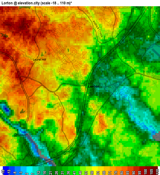
Below is the Elevation map of Lorton, which displays elevation range with different colors. Scale of the first map is from -18 to 110 m (-59 to 361 ft) with average elevation of 50 meters (=164 ft) [note 1]
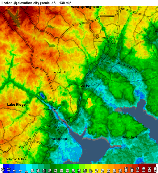
These maps also provides idea of topography and contour of this city, they are displayed at different zoom levels. More info about maps, scale and edge coordinates you can find below images.
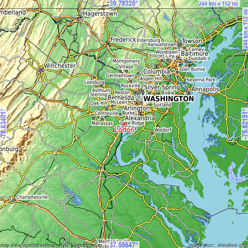
| \ | Map #1 | Map #2 | Topo.Map |
| Scale [m] | -18..110 m | -18..130 m | × |
| Scale [ft] | -59..361 ft | -59..427 ft | × |
| Average | 50 m = 164 ft | 57 m = 187 ft | × |
| Width | 7.63 km = 4.7 mi | 15.25 km = 9.5 mi | 244 km = 151.6 mi |
| Height | 7.63 km = 4.7 mi | 15.25 km = 9.5 mi | 244 km = 151.6 mi |
| ↑Max Latitude | 38.738566° | 38.772836° | 39.79325° |
| Latitude at center | 38.70428° | 38.70428° | 38.70428° |
| ↓Min Latitude | 38.669978° | 38.635659° | 37.59847° |
| ← Min Longitude | -77.271705° | -77.315651° | -78.63401° |
| Longitude center | -77.22776° | -77.22776° | -77.22776° |
| →Max Longitude | -77.183815° | -77.139869° | -75.82151° |
Nearby cities:
Cities around Lorton sort by population:
• Dale City elevation 71 m
10.4 km,  224°
224°
• Lake Ridge 82 m
6.3 km,  253°
253°
• Springfield 77 m
10.1 km,  20°
20°
• West Springfield 92 m
7.6 km,  4°
4°
• Woodlawn 11 m
8.4 km,  80°
80°
• Newington 32 m
5.3 km,  44°
44°
• Fort Belvoir 43 m
7.2 km, 83°
• Laurel Hill 68 m
1.6 km,  330°
330°
• Potomac Mills 61 m
8.7 km, 221°
• Woodbridge 27 m
5.5 km,  200°
200°
• Hayfield 23 m
9.6 km,  56°
56°
• Occoquan 5 m
3.6 km,  230°
230°
Multilingual:
 En español:
Lorton elevación 47 m.
 En France:
Lorton élévation 47 m.


Sources and notes:
- [note 1] Map square and city borders are not equal. Map elevation data is calculated only from area inside that square.
- [src 1] Elevation data from geonames database provided with same terms of usage.
- [src 2] The elevation map of Lorton is generated using elevation data from NASA's 3 arcsec (90m) resolution SRTM data.
- [src 3] Base (background) map © OpenStreetMap contributors tiles are generated by Geofabrik and OpenTopoMap.
Copyright & License:
This Lorton Elevation Map is licensed under CC BY-SA. You may reuse any part from this page, if you give a proper credit by linking to this URL:
 More info on terms of use page.