Eagle River elevation
Eagle River (Alaska, Anchorage Municipality), United States elevation is 106 meters and Eagle River elevation in feet is 348 ft above sea level [src 1]. Eagle River is a populated place (feature code) with elevation that is 173 meters (568 ft) smaller than average city elevation in United States.
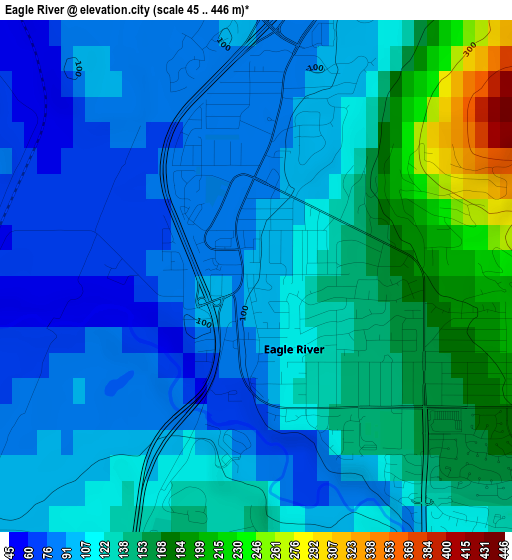
Below is the Elevation map of Eagle River, which displays elevation range with different colors. Scale of the first map is from 45 to 446 m (148 to 1463 ft) with average elevation of 120.4 meters (=395 ft) [note 1]
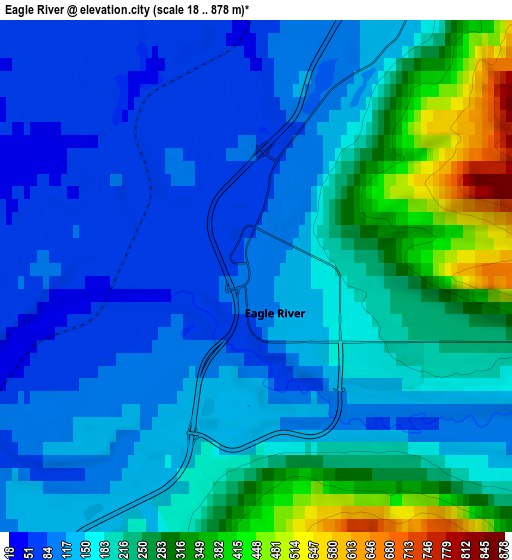
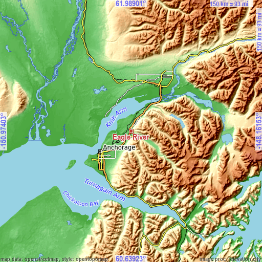
These maps also provides idea of topography and contour of this city, they are displayed at different zoom levels. More info about maps, scale and edge coordinates you can find below images.
| \ | Map #1 | Map #2 | Topo.Map |
| Scale [m] | 45..446 m | 18..878 m | × |
| Scale [ft] | 148..1463 ft | 59..2881 ft | × |
| Average | 120.4 m = 395 ft | 182.5 m = 599 ft | × |
| Width | 4.69 km = 2.9 mi | 9.38 km = 5.8 mi | 150.1 km = 93.3 mi |
| Height | 4.69 km = 2.9 mi | 9.38 km = 5.8 mi | 150.1 km = 93.3 mi |
| ↑Max Latitude | 61.342472° | 61.36354° | 61.98901° |
| Latitude at center | 61.32139° | 61.32139° | 61.32139° |
| ↓Min Latitude | 61.300294° | 61.279183° | 60.63923° |
| ← Min Longitude | -149.611725° | -149.655671° | -150.97403° |
| Longitude center | -149.56778° | -149.56778° | -149.56778° |
| →Max Longitude | -149.523835° | -149.479889° | -148.16153° |
Nearby cities:
Cities around Eagle River sort by population:
• Anchorage elevation 16 m
21.2 km,  237°
237°
• Knik-Fairview 51 m
21.3 km,  355°
355°
• Wasilla 121 m
29.6 km,  13°
13°
• Lakes 99 m
34.6 km,  23°
23°
• Tanaina 145 m
34.8 km, 12°
• Meadow Lakes 111 m
33.8 km, 356°
• Palmer 62 m
39.2 km,  37°
37°
• Elmendorf Air Force Base 185 m
7.9 km,  205°
205°
• Gateway 60 m
32.9 km,  31°
31°
• Big Lake 43 m
30.3 km,  317°
317°
• Butte 30 m
37.6 km,  49°
49°
• Houston 75 m
36.8 km,  338°
338°
Multilingual:
 En español:
Eagle River elevación 106 m.
 En France:
Eagle River élévation 106 m.
 Auf Deutsch:
Eagle River höhe über dem Meeresspiegel ist 106 m.

Sources and notes:
- [note 1] Map square and city borders are not equal. Map elevation data is calculated only from area inside that square.
- [src 1] Elevation data from geonames database provided with same terms of usage.
- [src 2] The elevation map of Eagle River is generated using GMTED2010 database with 7.5 arcsec (225m) resolution.
- [src 3] Base (background) map © OpenStreetMap contributors tiles are generated by Geofabrik and OpenTopoMap.
Copyright & License:
This Eagle River Elevation Map is licensed under CC BY-SA. You may reuse any part from this page, if you give a proper credit by linking to this URL:
 More info on terms of use page.