Sedro-Woolley elevation
Sedro-Woolley (Washington, Skagit County), United States elevation is 18 meters and Sedro-Woolley elevation in feet is 59 ft above sea level [src 1]. Sedro-Woolley is a populated place (feature code) with elevation that is 261 meters (856 ft) smaller than average city elevation in United States.
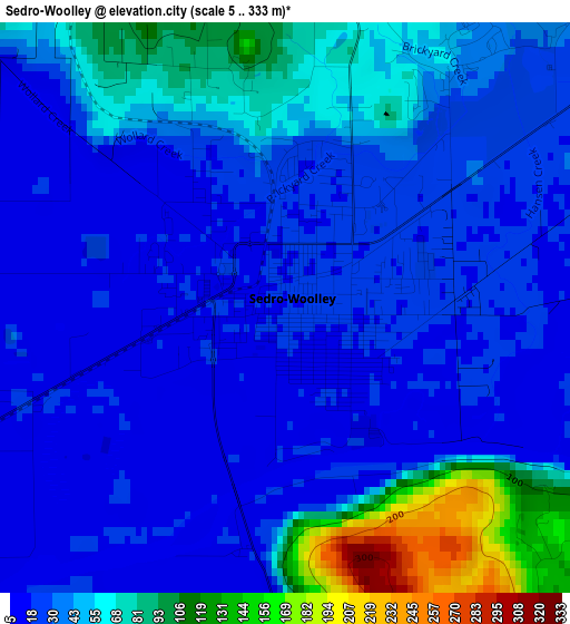
Below is the Elevation map of Sedro-Woolley, which displays elevation range with different colors. Scale of the first map is from 5 to 333 m (16 to 1093 ft) with average elevation of 41.4 meters (=136 ft) [note 1]
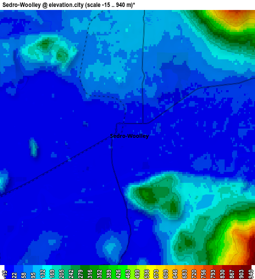
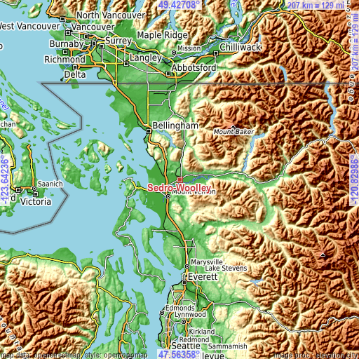
These maps also provides idea of topography and contour of this city, they are displayed at different zoom levels. More info about maps, scale and edge coordinates you can find below images.
| \ | Map #1 | Map #2 | Topo.Map |
| Scale [m] | 5..333 m | -15..940 m | × |
| Scale [ft] | 16..1093 ft | -49..3084 ft | × |
| Average | 41.4 m = 136 ft | 85.2 m = 280 ft | × |
| Width | 6.47 km = 4 mi | 12.95 km = 8 mi | 207.2 km = 128.7 mi |
| Height | 6.47 km = 4 mi | 12.95 km = 8 mi | 207.2 km = 128.7 mi |
| ↑Max Latitude | 48.532998° | 48.56209° | 49.42708° |
| Latitude at center | 48.50389° | 48.50389° | 48.50389° |
| ↓Min Latitude | 48.474765° | 48.445623° | 47.56358° |
| ← Min Longitude | -122.280055° | -122.324001° | -123.64236° |
| Longitude center | -122.23611° | -122.23611° | -122.23611° |
| →Max Longitude | -122.192165° | -122.148219° | -120.82986° |
Nearby cities:
Cities around Sedro-Woolley sort by population:
• Bellingham elevation 21 m
33.9 km,  326°
326°
• Mount Vernon 27 m
11.7 km,  218°
218°
• Arlington 33 m
34.9 km,  166°
166°
• Anacortes 4 m
27.8 km,  271°
271°
• Burlington 10 m
7.3 km,  244°
244°
• Stanwood 1 m
30.9 km,  198°
198°
• Sudden Valley 220 m
25.7 km,  341°
341°
• Geneva 144 m
29.5 km, 335°
• Arlington Heights 94 m
35.9 km,  159°
159°
• Bryant 52 m
30 km, 168°
• Big Lake 30 m
11.2 km,  181°
181°
• Clear Lake 14 m
4.4 km, 178°
Multilingual:
 En español:
Sedro-Woolley elevación 18 m.
 En France:
Sedro-Woolley élévation 18 m.
 Auf Deutsch:
Sedro-Woolley höhe über dem Meeresspiegel ist 18 m.

Sources and notes:
- [note 1] Map square and city borders are not equal. Map elevation data is calculated only from area inside that square.
- [src 1] Elevation data from geonames database provided with same terms of usage.
- [src 2] The elevation map of Sedro-Woolley is generated using elevation data from NASA's 3 arcsec (90m) resolution SRTM data.
- [src 3] Base (background) map © OpenStreetMap contributors tiles are generated by Geofabrik and OpenTopoMap.
Copyright & License:
This Sedro-Woolley Elevation Map is licensed under CC BY-SA. You may reuse any part from this page, if you give a proper credit by linking to this URL:
 More info on terms of use page.