Big Lake elevation
Big Lake (Washington, Skagit County), United States elevation is 30 meters and Big Lake elevation in feet is 98 ft above sea level [src 1]. Big Lake is a populated place (feature code) with elevation that is 249 meters (817 ft) smaller than average city elevation in United States.
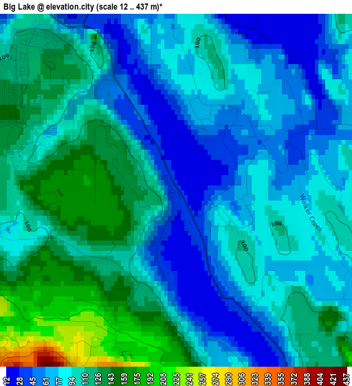
Below is the Elevation map of Big Lake, which displays elevation range with different colors. Scale of the first map is from 12 to 437 m (39 to 1434 ft) with average elevation of 97.1 meters (=319 ft) [note 1]
These maps also provides idea of topography and contour of this city, they are displayed at different zoom levels. More info about maps, scale and edge coordinates you can find below images.
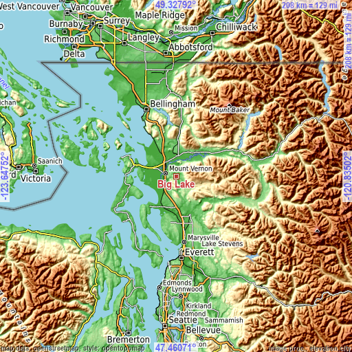
| \ | Map #1 | Topo.Map |
| Scale [m] | 12..437 m | × |
| Scale [ft] | 39..1434 ft | × |
| Average | 97.1 m = 319 ft | × |
| Width | 6.49 km = 4 mi | 207.6 km = 129 mi |
| Height | 6.49 km = 4 mi | 207.6 km = 129 mi |
| ↑Max Latitude | 48.432046° | 49.32792° |
| Latitude at center | 48.40288° | 48.40288° |
| ↓Min Latitude | 48.373697° | 47.46071° |
| ← Min Longitude | -122.285215° | -123.64752° |
| Longitude center | -122.24127° | -122.24127° |
| →Max Longitude | -122.197325° | -120.83502° |
Nearby cities:
Cities around Big Lake sort by population:
• Mount Vernon elevation 27 m
7.1 km,  286°
286°
• Oak Harbor 27 m
32.1 km,  247°
247°
• Arlington 33 m
24.3 km,  159°
159°
• Anacortes 4 m
30 km, 294°
• Sedro-Woolley 18 m
11.2 km,  1°
1°
• Burlington 10 m
10.2 km,  322°
322°
• Stanwood 1 m
20.4 km,  208°
208°
• Warm Beach 19 m
27.4 km,  199°
199°
• Arlington Heights 94 m
26 km,  149°
149°
• Bryant 52 m
19.2 km, 161°
• Smokey Point 39 m
28.2 km,  171°
171°
• Clear Lake 14 m
6.8 km, 4°
Multilingual:
 En español:
Big Lake elevación 30 m.
 En France:
Big Lake élévation 30 m.


Sources and notes:
- [note 1] Map square and city borders are not equal. Map elevation data is calculated only from area inside that square.
- [src 1] Elevation data from geonames database provided with same terms of usage.
- [src 2] The elevation map of Big Lake is generated using elevation data from NASA's 3 arcsec (90m) resolution SRTM data.
- [src 3] Base (background) map © OpenStreetMap contributors tiles are generated by Geofabrik and OpenTopoMap.
Copyright & License:
This Big Lake Elevation Map is licensed under CC BY-SA. You may reuse any part from this page, if you give a proper credit by linking to this URL:
 More info on terms of use page.