Mukilteo elevation
Mukilteo (Washington, Snohomish County), United States elevation is 39 meters and Mukilteo elevation in feet is 128 ft above sea level [src 1]. Mukilteo is a populated place (feature code) with elevation that is 240 meters (787 ft) smaller than average city elevation in United States.
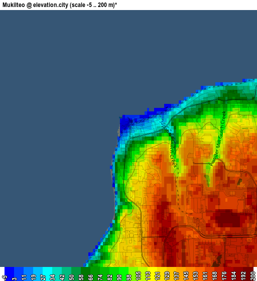
Below is the Elevation map of Mukilteo, which displays elevation range with different colors. Scale of the first map is from -5 to 200 m (-16 to 656 ft) with average elevation of 125.2 meters (=411 ft) [note 1]
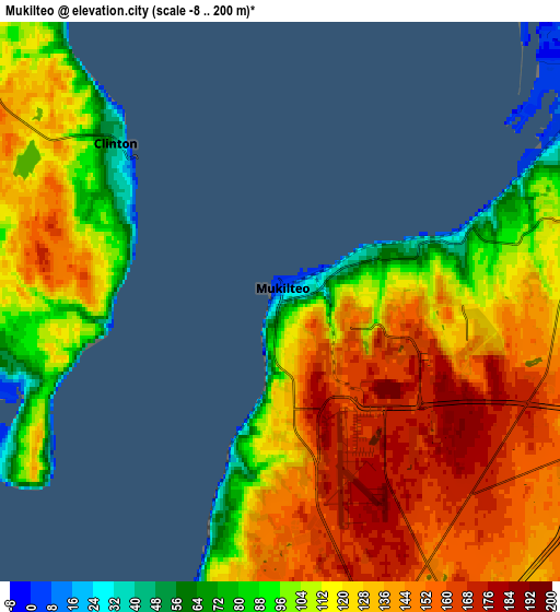
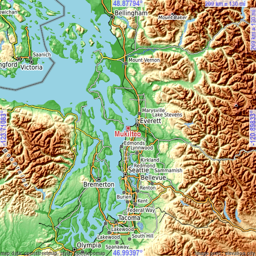
These maps also provides idea of topography and contour of this city, they are displayed at different zoom levels. More info about maps, scale and edge coordinates you can find below images.
| \ | Map #1 | Map #2 | Topo.Map |
| Scale [m] | -5..200 m | -8..200 m | × |
| Scale [ft] | -16..656 ft | -26..656 ft | × |
| Average | 125.2 m = 411 ft | 123.8 m = 406 ft | × |
| Width | 6.55 km = 4.1 mi | 13.09 km = 8.1 mi | 209.5 km = 130.2 mi |
| Height | 6.55 km = 4.1 mi | 13.09 km = 8.1 mi | 209.5 km = 130.2 mi |
| ↑Max Latitude | 47.973968° | 48.00338° | 48.87794° |
| Latitude at center | 47.94454° | 47.94454° | 47.94454° |
| ↓Min Latitude | 47.915095° | 47.885633° | 46.99397° |
| ← Min Longitude | -122.348525° | -122.392471° | -123.71083° |
| Longitude center | -122.30458° | -122.30458° | -122.30458° |
| →Max Longitude | -122.260635° | -122.216689° | -120.89833° |
Nearby cities:
Cities around Mukilteo sort by population:
• Everett elevation 22 m
8.5 km,  63°
63°
• Picnic Point-North Lynnwood 153 m
9.1 km,  175°
175°
• Eastmont 118 m
10.6 km,  119°
119°
• Mill Creek 126 m
12 km,  141°
141°
• Martha Lake 146 m
11.5 km,  154°
154°
• Picnic Point 47 m
7.3 km,  194°
194°
• Alderwood Manor 127 m
13.7 km,  172°
172°
• Lake Stickney 146 m
8.2 km,  157°
157°
• Larch Way 156 m
11.9 km, 161°
• Meadowdale 41 m
10.4 km, 191°
• Tulalip Bay 1 m
10.3 km,  357°
357°
• Langley 21 m
13 km,  324°
324°
Multilingual:
 En español:
Mukilteo elevación 39 m.
 En France:
Mukilteo élévation 39 m.


Sources and notes:
- [note 1] Map square and city borders are not equal. Map elevation data is calculated only from area inside that square.
- [src 1] Elevation data from geonames database provided with same terms of usage.
- [src 2] The elevation map of Mukilteo is generated using elevation data from NASA's 3 arcsec (90m) resolution SRTM data.
- [src 3] Base (background) map © OpenStreetMap contributors tiles are generated by Geofabrik and OpenTopoMap.
Copyright & License:
This Mukilteo Elevation Map is licensed under CC BY-SA. You may reuse any part from this page, if you give a proper credit by linking to this URL:
 More info on terms of use page.