Everett elevation
Everett (Washington, Snohomish County), United States elevation is 22 meters and Everett elevation in feet is 72 ft above sea level [src 1]. Everett is a seat of a second-order administrative division (feature code) with elevation that is 257 meters (843 ft) smaller than average city elevation in United States.
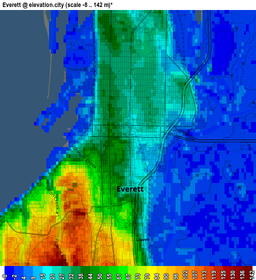
Below is the Elevation map of Everett, which displays elevation range with different colors. Scale of the first map is from -8 to 142 m (-26 to 466 ft) with average elevation of 26.4 meters (=87 ft) [note 1]
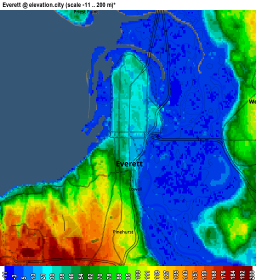
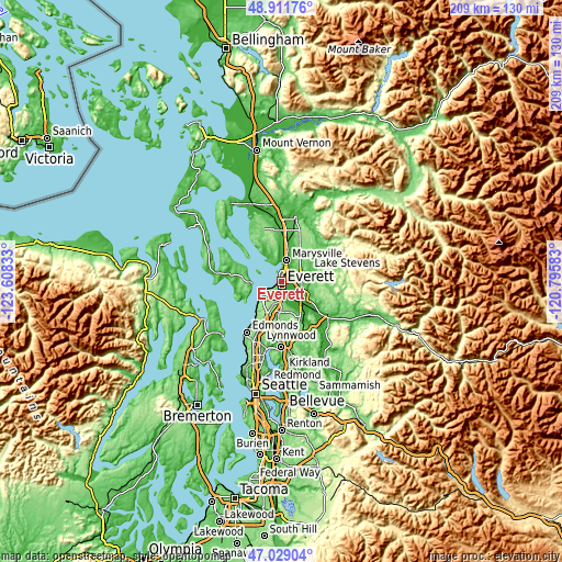
These maps also provides idea of topography and contour of this city, they are displayed at different zoom levels. More info about maps, scale and edge coordinates you can find below images.
| \ | Map #1 | Map #2 | Topo.Map |
| Scale [m] | -8..142 m | -11..200 m | × |
| Scale [ft] | -26..466 ft | -36..656 ft | × |
| Average | 26.4 m = 87 ft | 47.6 m = 156 ft | × |
| Width | 6.54 km = 4.1 mi | 13.08 km = 8.1 mi | 209.3 km = 130.1 mi |
| Height | 6.54 km = 4.1 mi | 13.08 km = 8.1 mi | 209.3 km = 130.1 mi |
| ↑Max Latitude | 48.008389° | 48.037781° | 48.91176° |
| Latitude at center | 47.97898° | 47.97898° | 47.97898° |
| ↓Min Latitude | 47.949554° | 47.920112° | 47.02904° |
| ← Min Longitude | -122.246025° | -122.289971° | -123.60833° |
| Longitude center | -122.20208° | -122.20208° | -122.20208° |
| →Max Longitude | -122.158135° | -122.114189° | -120.79583° |
Nearby cities:
Cities around Everett sort by population:
• Marysville elevation 6 m
8.3 km,  12°
12°
• Lake Stevens 67 m
11 km,  68°
68°
• Mukilteo 39 m
8.5 km,  243°
243°
• West Lake Stevens 112 m
7.6 km,  77°
77°
• Eastmont 118 m
9.2 km,  170°
170°
• Snohomish 17 m
10.7 km,  133°
133°
• Tulalip 33 m
12 km,  326°
326°
• Lake Stickney 146 m
12.2 km,  201°
201°
• Bunk Foss 121 m
8.2 km,  103°
103°
• Fobes Hill 62 m
7 km,  118°
118°
• Tulalip Bay 1 m
10.3 km,  308°
308°
• Machias 34 m
11.6 km,  88°
88°
Multilingual:
 En español:
Everett elevación 22 m.
 En France:
Everett élévation 22 m.


Sources and notes:
- [note 1] Map square and city borders are not equal. Map elevation data is calculated only from area inside that square.
- [src 1] Elevation data from geonames database provided with same terms of usage.
- [src 2] The elevation map of Everett is generated using elevation data from NASA's 3 arcsec (90m) resolution SRTM data.
- [src 3] Base (background) map © OpenStreetMap contributors tiles are generated by Geofabrik and OpenTopoMap.
Copyright & License:
This Everett Elevation Map is licensed under CC BY-SA. You may reuse any part from this page, if you give a proper credit by linking to this URL:
 More info on terms of use page.