Monroe elevation
Monroe (Washington, Snohomish County), United States elevation is 22 meters and Monroe elevation in feet is 72 ft above sea level [src 1]. Monroe is a populated place (feature code) with elevation that is 257 meters (843 ft) smaller than average city elevation in United States.
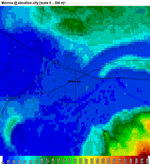
Below is the Elevation map of Monroe, which displays elevation range with different colors. Scale of the first map is from 0 to 394 m (0 to 1293 ft) with average elevation of 51.4 meters (=169 ft) [note 1]
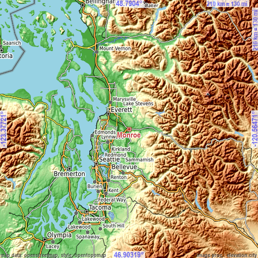
These maps also provides idea of topography and contour of this city, they are displayed at different zoom levels. More info about maps, scale and edge coordinates you can find below images.
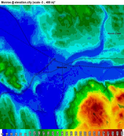
| \ | Map #1 | Map #2 | Topo.Map |
| Scale [m] | 0..394 m | -3..488 m | × |
| Scale [ft] | 0..1293 ft | -10..1601 ft | × |
| Average | 51.4 m = 169 ft | 106 m = 348 ft | × |
| Width | 6.56 km = 4.1 mi | 13.11 km = 8.1 mi | 209.8 km = 130.4 mi |
| Height | 6.56 km = 4.1 mi | 13.11 km = 8.1 mi | 209.8 km = 130.4 mi |
| ↑Max Latitude | 47.884859° | 47.914321° | 48.7904° |
| Latitude at center | 47.85538° | 47.85538° | 47.85538° |
| ↓Min Latitude | 47.825884° | 47.796371° | 46.90319° |
| ← Min Longitude | -122.014905° | -122.058851° | -123.37721° |
| Longitude center | -121.97096° | -121.97096° | -121.97096° |
| →Max Longitude | -121.927015° | -121.883069° | -120.56471° |
Nearby cities:
Cities around Monroe sort by population:
• Cottage Lake elevation 75 m
14.7 km,  212°
212°
• Silver Firs 158 m
13.8 km,  274°
274°
• Maltby 119 m
12 km,  242°
242°
• Snohomish 17 m
11.4 km,  303°
303°
• Duvall 26 m
12.6 km,  184°
184°
• Woods Creek 110 m
6 km,  64°
64°
• Sultan 36 m
11.6 km,  86°
86°
• Bunk Foss 121 m
15 km,  322°
322°
• Clearview 183 m
11.8 km,  258°
258°
• Three Lakes 146 m
10.4 km,  343°
343°
• Cathcart 69 m
9.6 km, 265°
• Monroe North 78 m
3.2 km, 337°
Multilingual:
 En español:
Monroe elevación 22 m.
 En France:
Monroe élévation 22 m.


Sources and notes:
- [note 1] Map square and city borders are not equal. Map elevation data is calculated only from area inside that square.
- [src 1] Elevation data from geonames database provided with same terms of usage.
- [src 2] The elevation map of Monroe is generated using elevation data from NASA's 3 arcsec (90m) resolution SRTM data.
- [src 3] Base (background) map © OpenStreetMap contributors tiles are generated by Geofabrik and OpenTopoMap.
Copyright & License:
This Monroe Elevation Map is licensed under CC BY-SA. You may reuse any part from this page, if you give a proper credit by linking to this URL:
 More info on terms of use page.