Cathcart elevation
Cathcart (Washington, Snohomish County), United States elevation is 69 meters and Cathcart elevation in feet is 226 ft above sea level [src 1]. Cathcart is a populated place (feature code) with elevation that is 210 meters (689 ft) smaller than average city elevation in United States.
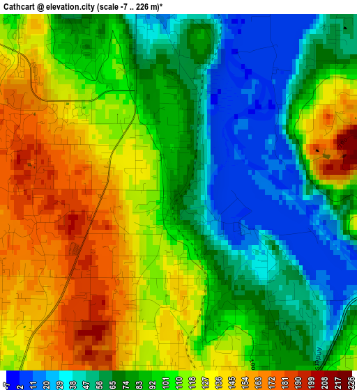
Below is the Elevation map of Cathcart, which displays elevation range with different colors. Scale of the first map is from -7 to 226 m (-23 to 741 ft) with average elevation of 97.9 meters (=321 ft) [note 1]
These maps also provides idea of topography and contour of this city, they are displayed at different zoom levels. More info about maps, scale and edge coordinates you can find below images.
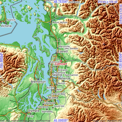
| \ | Map #1 | Topo.Map |
| Scale [m] | -7..226 m | × |
| Scale [ft] | -23..741 ft | × |
| Average | 97.9 m = 321 ft | × |
| Width | 6.56 km = 4.1 mi | 209.9 km = 130.4 mi |
| Height | 6.56 km = 4.1 mi | 209.9 km = 130.4 mi |
| ↑Max Latitude | 47.877363° | 48.78304° |
| Latitude at center | 47.84788° | 47.84788° |
| ↓Min Latitude | 47.81838° | 46.89555° |
| ← Min Longitude | -122.143235° | -123.50554° |
| Longitude center | -122.09929° | -122.09929° |
| →Max Longitude | -122.055345° | -120.69304° |
Nearby cities:
Cities around Cathcart sort by population:
• North Creek elevation 114 m
6.6 km,  241°
241°
• Silver Firs 158 m
4.6 km,  295°
295°
• Eastmont 118 m
8.2 km,  311°
311°
• Mill Creek 126 m
8 km,  279°
279°
• Monroe 22 m
9.6 km,  85°
85°
• Mill Creek East 116 m
6.7 km,  258°
258°
• Martha Lake 146 m
10.5 km,  271°
271°
• Maltby 119 m
4.9 km,  192°
192°
• Snohomish 17 m
7.2 km,  0°
0°
• Bothell East 118 m
7.8 km,  233°
233°
• Clearview 183 m
2.5 km, 231°
• Monroe North 78 m
9.2 km,  65°
65°
Multilingual:
 En español:
Cathcart elevación 69 m.
 En France:
Cathcart élévation 69 m.


Sources and notes:
- [note 1] Map square and city borders are not equal. Map elevation data is calculated only from area inside that square.
- [src 1] Elevation data from geonames database provided with same terms of usage.
- [src 2] The elevation map of Cathcart is generated using elevation data from NASA's 3 arcsec (90m) resolution SRTM data.
- [src 3] Base (background) map © OpenStreetMap contributors tiles are generated by Geofabrik and OpenTopoMap.
Copyright & License:
This Cathcart Elevation Map is licensed under CC BY-SA. You may reuse any part from this page, if you give a proper credit by linking to this URL:
 More info on terms of use page.